Castroverde geodata
Castroverde (Galicia) is a seat of a third-order administrative division; located in Spain in Europe/Madrid (GMT+2) time zone. With population of 3,218 people, there are 1656 cities with bigger population in this country. Compared to other cities in Spain, 94.6% of cities are located further ↓South; 95.1% of cities are located further →East and 56.2% of cities have higher elevation than Castroverde. Note1


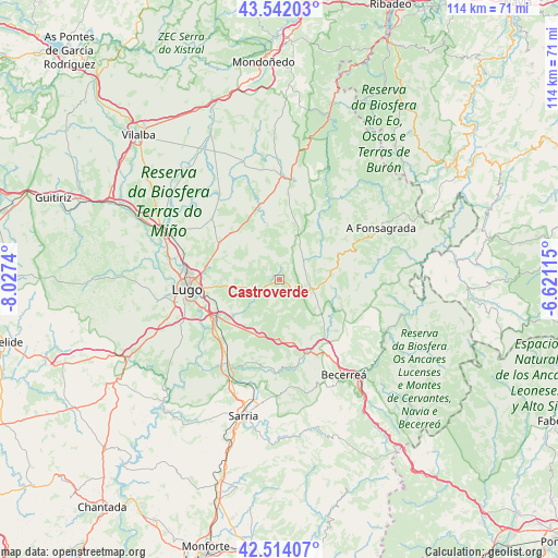
Castroverde GPS coordinates[2]
43° 1' 48.72" North, 7° 19' 27.408" West
| Map corner | latitude | longitude |
|---|---|---|
| Upper-left | 43.54203°, | -8.0274° |
| Center: | 43.0302°, | -7.32428° |
| Lower-right: | 42.51407°, | -6.62115° |
| Map W x H: | 114.3×114.3 km | = 71×71mi |
| max Lat: | 43.74134° ⇑5.4% North |
| Castroverde: | 43.0302° |
| min Lat: | ⇓94.6% South 27.64134° |
| min Long | Castroverde | max Long |
| -18.00367° | -7.32428° | 4.2899° |
| W 4.9%⇐ | ⇒95.1% E |
Elevation
Elevation of Castroverde is 580 m = 1903 ft, and this is 18 m = 59 ft below average elevation for this country.
| Max E: |
1682 m = 5518 ft | 56.2% |
| Avg. | 598 m = 1962 ft | |
| Castroverde | 580 m = 1903 ft | |
Min E: |
0 m = 0 ft | 43.8% |
See also: Spain elevation on elevation.city.
Geographical zone
Castroverde is located in North temperate zone (between Tropic of Cancer and the Arctic Circle). Distance of this Northern Tropic circle is 2178.6 km =1353.7 mi to South.| Distance of | km | miles | from Castroverde |
|---|---|---|---|
| North Pole | 5222.6 | 3245.2 | to North |
| Arctic Circle | 2616.7 | 1625.9 | to North |
| Tropic Cancer | 2178.6 | 1353.7 | to South |
| Equator | 4784.5 | 2972.9 | to South |


Nearby cities:
15 places around Castroverde: (largest is in red/bold)
• Baralla
16.4 km =10.2 mi,  159°
159°
• Becerreá
23.4 km =14.5 mi,  145°
145°
• Castro de Rei
20.8 km =12.9 mi,  342°
342°
• Corgo
12.9 km =8 mi,  222°
222°
• Fonsagrada
23.3 km =14.5 mi,  63°
63°
• Lugo
19 km =11.8 mi,  263°
263°
• Láncara
18.5 km =11.5 mi,  183°
183°
• Meira
20.5 km =12.7 mi,  6°
6°
• Mos
23.1 km =14.4 mi,  307°
307°
• O Páramo
9.1 km =5.7 mi,  167°
167°
• Outeiro
13 km =8.1 mi, 11°
• Outeiro de Rei
24.9 km =15.5 mi,  288°
288°
• Piquín
17.2 km =10.7 mi,  35°
35°
• Pol
13.2 km =8.2 mi,  357°
357°
• Rábade
25.7 km =16 mi, 292°
Sources, notices
• [Note1] Compared only with cities in Spain existing in our database
• [Src1] Map data: © OpenStreetMap contributors (CC-BY-SA)
• [Src2] Other city data from geonames.org with taken over terms of usage.
• [Src3] Geographical zone / Annual Mean Temperature by Robert A. Rohde @ Wikipedia
