Castro de Rei geodata
Castro de Rei (Galicia) is a populated place; located in Spain in Europe/Madrid (GMT+2) time zone. With population of 5,685 people, there are 1178 cities with bigger population in this country. Compared to other cities in Spain, 96.5% of cities are located further ↓South; 95.2% of cities are located further →East and 66.9% of cities have higher elevation than Castro de Rei. Note1


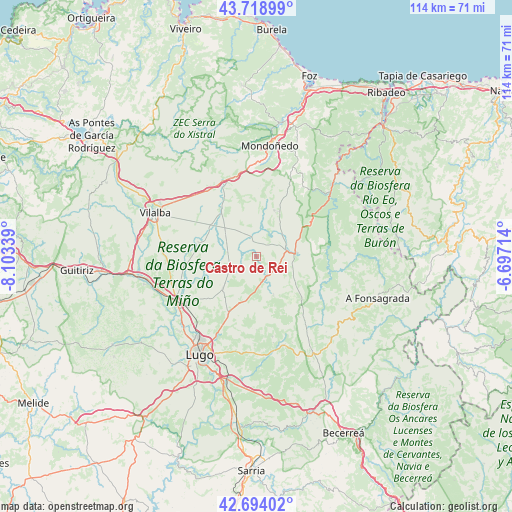
Castro de Rei GPS coordinates[2]
43° 12' 31.176" North, 7° 24' 0.936" West
| Map corner | latitude | longitude |
|---|---|---|
| Upper-left | 43.71899°, | -8.10339° |
| Center: | 43.20866°, | -7.40026° |
| Lower-right: | 42.69402°, | -6.69714° |
| Map W x H: | 114×114 km | = 70.8×70.8mi |
| max Lat: | 43.74134° ⇑3.5% North |
| Castro de Rei: | 43.20866° |
| min Lat: | ⇓96.5% South 27.64134° |
| min Long | Castro de Rei | max Long |
| -18.00367° | -7.40026° | 4.2899° |
| W 4.8%⇐ | ⇒95.2% E |
Elevation
Elevation of Castro de Rei is 435 m = 1427 ft, and this is 163 m = 535 ft below average elevation for this country.
| Max E: |
1682 m = 5518 ft | 66.9% |
| Avg. | 598 m = 1962 ft | |
| Castro de Rei | 435 m = 1427 ft | |
Min E: |
0 m = 0 ft | 33.1% |
See also: Spain elevation on elevation.city.
Geographical zone
Castro de Rei is located in North temperate zone (between Tropic of Cancer and the Arctic Circle). Distance of this Northern Tropic circle is 2198.4 km =1366 mi to South.| Distance of | km | miles | from Castro de Rei |
|---|---|---|---|
| North Pole | 5202.7 | 3232.8 | to North |
| Arctic Circle | 2596.8 | 1613.6 | to North |
| Tropic Cancer | 2198.4 | 1366 | to South |
| Equator | 4804.4 | 2985.3 | to South |


Nearby cities:
15 places around Castro de Rei: (largest is in red/bold)
• Abadín
18.8 km =11.7 mi,  339°
339°
• Begonte
24.1 km =15 mi,  254°
254°
• Castroverde
20.8 km =12.9 mi,  162°
162°
• Meira
8.6 km =5.3 mi,  86°
86°
• Mondoñedo
21.3 km =13.2 mi,  0°
0°
• Mondoñedo
24.5 km =15.2 mi,  7°
7°
• Mos
13.5 km =8.4 mi,  244°
244°
• Outeiro
11.3 km =7 mi,  129°
129°
• Outeiro de Rei
21.1 km =13.1 mi, 235°
• Piquín
17 km =10.6 mi,  109°
109°
• Pol
8.7 km =5.4 mi,  139°
139°
• Puente Nuevo
22.9 km =14.2 mi,  46°
46°
• Rábade
20.3 km =12.6 mi, 239°
• Ríotorto
20.7 km =12.9 mi,  40°
40°
• Vilalba
24.8 km =15.4 mi,  293°
293°
Sources, notices
• [Note1] Compared only with cities in Spain existing in our database
• [Src1] Map data: © OpenStreetMap contributors (CC-BY-SA)
• [Src2] Other city data from geonames.org with taken over terms of usage.
• [Src3] Geographical zone / Annual Mean Temperature by Robert A. Rohde @ Wikipedia
