Lugo geodata
Lugo (Galicia) is a seat of a second-order administrative division; located in Spain in Europe/Madrid (GMT+2) time zone. With population of 96,678 people, there are 91 cities with bigger population in this country. Compared to other cities in Spain, 94.4% of cities are located further ↓South; 95.5% of cities are located further →East and 64.6% of cities have higher elevation than Lugo. Note1


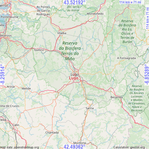
Lugo GPS coordinates[2]
43° 0' 35.712" North, 7° 33' 21.672" West
| Map corner | latitude | longitude |
|---|---|---|
| Upper-left | 43.52192°, | -8.25914° |
| Center: | 43.00992°, | -7.55602° |
| Lower-right: | 42.49362°, | -6.85289° |
| Map W x H: | 114.3×114.3 km | = 71×71mi |
| max Lat: | 43.74134° ⇑5.6% North |
| Lugo: | 43.00992° |
| min Lat: | ⇓94.4% South 27.64134° |
| min Long | Lugo | max Long |
| -18.00367° | -7.55602° | 4.2899° |
| W 4.5%⇐ | ⇒95.5% E |
Elevation
Elevation of Lugo is 465 m = 1526 ft, and this is 133 m = 436 ft below average elevation for this country.
| Max E: |
1682 m = 5518 ft | 64.6% |
| Avg. | 598 m = 1962 ft | |
| Lugo | 465 m = 1526 ft | |
Min E: |
0 m = 0 ft | 35.4% |
See also: Lugo elevation on elevation.city.
Geographical zone
Lugo is located in North temperate zone (between Tropic of Cancer and the Arctic Circle). Distance of this Northern Tropic circle is 2176.3 km =1352.3 mi to South.| Distance of | km | miles | from Lugo |
|---|---|---|---|
| North Pole | 5224.8 | 3246.5 | to North |
| Arctic Circle | 2618.9 | 1627.3 | to North |
| Tropic Cancer | 2176.3 | 1352.3 | to South |
| Equator | 4782.3 | 2971.6 | to South |


Nearby cities:
15 places around Lugo: (largest is in red/bold)
• Begonte
18.9 km =11.7 mi,  326°
326°
• Castro de Rei
25.5 km =15.8 mi,  29°
29°
• Castroverde
19 km =11.8 mi,  83°
83°
• Corgo
12.5 km =7.8 mi,  125°
125°
• Friol
19.6 km =12.2 mi,  277°
277°
• Guntín
17.6 km =10.9 mi,  219°
219°
• Láncara
24.1 km =15 mi, 132°
• Mos
16.3 km =10.1 mi,  1°
1°
• O Páramo
21.9 km =13.6 mi,  107°
107°
• Ourol
16.3 km =10.1 mi,  197°
197°
• Outeiro
26.1 km =16.2 mi,  55°
55°
• Outeiro de Rei
11.3 km =7 mi, 334°
• Pol
24 km =14.9 mi,  49°
49°
• Portomarín
23.2 km =14.4 mi,  192°
192°
• Rábade
12.9 km =8 mi,  337°
337°
Sources, notices
• [Note1] Compared only with cities in Spain existing in our database
• [Src1] Map data: © OpenStreetMap contributors (CC-BY-SA)
• [Src2] Other city data from geonames.org with taken over terms of usage.
• [Src3] Geographical zone / Annual Mean Temperature by Robert A. Rohde @ Wikipedia
