Castejón de Sos geodata
Castejón de Sos (Aragon) is a seat of a third-order administrative division; located in Spain in Europe/Madrid (GMT+2) time zone. With population of 781 people, there are 3249 cities with bigger population in this country. Compared to other cities in Spain, 87.5% of cities are located further ↓South; 88.9% of cities are located further ←West and 82.2% of cities have lower elevation than Castejón de Sos. Note1


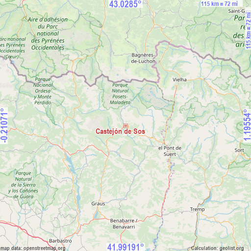
Castejón de Sos GPS coordinates[2]
42° 30' 44.46" North, 0° 29' 32.676" East
| Map corner | latitude | longitude |
|---|---|---|
| Upper-left | 43.0285°, | -0.21071° |
| Center: | 42.51235°, | 0.49241° |
| Lower-right: | 41.99191°, | 1.19554° |
| Map W x H: | 115.3×115.3 km | = 71.6×71.6mi |
| max Lat: | 43.74134° ⇑12.5% North |
| Castejón de Sos: | 42.51235° |
| min Lat: | ⇓87.5% South 27.64134° |
| min Long | Castejón de So | max Long |
| -18.00367° | 0.49241° | 4.2899° |
| W 88.9%⇐ | ⇒11.1% E |
Elevation
Elevation of Castejón de Sos is 919 m = 3015 ft, and this is 321 m = 1053 ft above average elevation for this country.
| Max E: |
1682 m = 5518 ft | 17.8% |
| Castejón de Sos | 919 m 3015 ft | |
| Avg. | 598 m = 1962 ft | |
Min E: |
0 m = 0 ft | 82.2% |
See also: Spain elevation on elevation.city.
Geographical zone
Castejón de Sos is located in North temperate zone (between Tropic of Cancer and the Arctic Circle). Distance of this Northern Tropic circle is 2121 km =1317.9 mi to South.| Distance of | km | miles | from Castejón de Sos |
|---|---|---|---|
| North Pole | 5280.1 | 3280.9 | to North |
| Arctic Circle | 2674.2 | 1661.7 | to North |
| Tropic Cancer | 2121 | 1317.9 | to South |
| Equator | 4726.9 | 2937.2 | to South |


Nearby cities:
15 places around Castejón de Sos: (largest is in red/bold)
• Barruera
25.3 km =15.7 mi,  91°
91°
• Benasque
10.6 km =6.6 mi,  13°
13°
• Beranuy
18.2 km =11.3 mi,  152°
152°
• Bisaurri
2.1 km =1.3 mi, 146°
• Bonansa
17.2 km =10.7 mi,  123°
123°
• Campo
13.9 km =8.6 mi,  214°
214°
• Chía
2.4 km =1.5 mi,  293°
293°
• Gistaín
15.6 km =9.7 mi,  304°
304°
• Laspaúles
9.7 km =6 mi, 117°
• Plan
14.8 km =9.2 mi, 301°
• Sahún
7.4 km =4.6 mi,  342°
342°
• Seira
6.4 km =4 mi,  231°
231°
• Sesué
4.6 km =2.9 mi, 339°
• Vilaller
18.8 km =11.7 mi,  102°
102°
• Villanova
4.6 km =2.9 mi,  326°
326°
Sources, notices
• [Note1] Compared only with cities in Spain existing in our database
• [Src1] Map data: © OpenStreetMap contributors (CC-BY-SA)
• [Src2] Other city data from geonames.org with taken over terms of usage.
• [Src3] Geographical zone / Annual Mean Temperature by Robert A. Rohde @ Wikipedia
