Chía geodata
Chía (Aragon) is a seat of a third-order administrative division; located in Spain in Europe/Madrid (GMT+2) time zone. With population of 114 people, there are 5769 cities with bigger population in this country. Compared to other cities in Spain, 87.7% of cities are located further ↓South; 88.8% of cities are located further ←West and 97% of cities have lower elevation than Chía. Note1


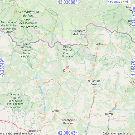
Chía GPS coordinates[2]
42° 31' 14.88" North, 0° 27' 56.268" East
| Map corner | latitude | longitude |
|---|---|---|
| Upper-left | 43.03688°, | -0.23749° |
| Center: | 42.5208°, | 0.46563° |
| Lower-right: | 42.00043°, | 1.16876° |
| Map W x H: | 115.2×115.2 km | = 71.6×71.6mi |
| max Lat: | 43.74134° ⇑12.3% North |
| Chía: | 42.5208° |
| min Lat: | ⇓87.7% South 27.64134° |
| min Long | Chía | max Long |
| -18.00367° | 0.46563° | 4.2899° |
| W 88.8%⇐ | ⇒11.2% E |
Elevation
Elevation of Chía is 1206 m = 3957 ft, and this is 608 m = 1995 ft above average elevation for this country.
| Max E: |
1682 m = 5518 ft | 3% |
| Chía | 1206 m 3957 ft | |
| Avg. | 598 m = 1962 ft | |
Min E: |
0 m = 0 ft | 97% |
See also: Spain elevation on elevation.city.
Geographical zone
Chía is located in North temperate zone (between Tropic of Cancer and the Arctic Circle). Distance of this Northern Tropic circle is 2122 km =1318.5 mi to South.| Distance of | km | miles | from Chía |
|---|---|---|---|
| North Pole | 5279.2 | 3280.3 | to North |
| Arctic Circle | 2673.3 | 1661.1 | to North |
| Tropic Cancer | 2122 | 1318.5 | to South |
| Equator | 4727.9 | 2937.8 | to South |


Nearby cities:
15 places around Chía: (largest is in red/bold)
• Benasque
10.5 km =6.5 mi,  26°
26°
• Beranuy
20.1 km =12.5 mi,  148°
148°
• Bielsa
23.8 km =14.8 mi,  301°
301°
• Bisaurri
4.3 km =2.7 mi,  128°
128°
• Bonansa
19.5 km =12.1 mi,  122°
122°
• Campo
13.6 km =8.5 mi,  204°
204°
• Castejón de Sos
2.4 km =1.5 mi,  113°
113°
• Gistaín
13.3 km =8.3 mi,  306°
306°
• Laspaúles
12.1 km =7.5 mi, 117°
• Plan
12.5 km =7.8 mi, 302°
• Sahún
6.1 km =3.8 mi,  359°
359°
• Seira
5.6 km =3.5 mi,  210°
210°
• Sesué
3.4 km =2.1 mi,  8°
8°
• Vilaller
21.2 km =13.2 mi,  103°
103°
• Villanova
2.9 km =1.8 mi,  353°
353°
Sources, notices
• [Note1] Compared only with cities in Spain existing in our database
• [Src1] Map data: © OpenStreetMap contributors (CC-BY-SA)
• [Src2] Other city data from geonames.org with taken over terms of usage.
• [Src3] Geographical zone / Annual Mean Temperature by Robert A. Rohde @ Wikipedia
