Caracena geodata
Caracena (Castille and León) is a seat of a third-order administrative division; located in Spain in Europe/Madrid (GMT+2) time zone. With population of 17 people, there are 6739 cities with bigger population in this country. Compared to other cities in Spain, 57.2% of cities are located further ↓South; 52.9% of cities are located further ←West and 92.4% of cities have lower elevation than Caracena. Note1
Administrative division(s):
- Level 1: Castille and León
- Level 2: Provincia de Soria
- Level 3: Caracena


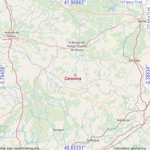
Caracena GPS coordinates[2]
41° 22' 59.556" North, 3° 5' 29.256" West
| Map corner | latitude | longitude |
|---|---|---|
| Upper-left | 41.90863°, | -3.79459° |
| Center: | 41.38321°, | -3.09146° |
| Lower-right: | 40.85351°, | -2.38834° |
| Map W x H: | 117.3×117.3 km | = 72.9×72.9mi |
| max Lat: | 43.74134° ⇑42.8% North |
| Caracena: | 41.38321° |
| min Lat: | ⇓57.2% South 27.64134° |
| min Long | Caracena | max Long |
| -18.00367° | -3.09146° | 4.2899° |
| W 52.9%⇐ | ⇒47.1% E |
Elevation
Elevation of Caracena is 1081 m = 3547 ft, and this is 483 m = 1585 ft above average elevation for this country.
| Max E: |
1682 m = 5518 ft | 7.6% |
| Caracena | 1081 m 3547 ft | |
| Avg. | 598 m = 1962 ft | |
Min E: |
0 m = 0 ft | 92.4% |
See also: Spain elevation on elevation.city.
Geographical zone
Caracena is located in North temperate zone (between Tropic of Cancer and the Arctic Circle). Distance of this Northern Tropic circle is 1995.5 km =1239.9 mi to South.| Distance of | km | miles | from Caracena |
|---|---|---|---|
| North Pole | 5405.7 | 3358.9 | to North |
| Arctic Circle | 2799.8 | 1739.7 | to North |
| Tropic Cancer | 1995.5 | 1239.9 | to South |
| Equator | 4601.4 | 2859.2 | to South |


Nearby cities:
15 places around Caracena: (largest is in red/bold)
• Albendiego
17.6 km =10.9 mi,  169°
169°
• Campisábalos
13.4 km =8.3 mi,  195°
195°
• Carrascosa de Abajo
4.5 km =2.8 mi,  2°
2°
• Fresno de Caracena
7.7 km =4.8 mi, 0°
• Gormaz
14.1 km =8.8 mi,  30°
30°
• Hijes
16.5 km =10.3 mi,  152°
152°
• Liceras
12.7 km =7.9 mi,  268°
268°
• Miedes de Atienza
16.8 km =10.4 mi,  140°
140°
• Montejo de Tiermes
9.2 km =5.7 mi,  259°
259°
• Quintanas de Gormaz
17 km =10.6 mi, 34°
• Recuerda
12.9 km =8 mi,  38°
38°
• Retortillo de Soria
12.2 km =7.6 mi,  131°
131°
• Somolinos
15.5 km =9.6 mi, 170°
• Ujados
18 km =11.2 mi,  156°
156°
• Villanueva de Gormaz
9.7 km =6 mi,  14°
14°
Sources, notices
• [Note1] Compared only with cities in Spain existing in our database
• [Src1] Map data: © OpenStreetMap contributors (CC-BY-SA)
• [Src2] Other city data from geonames.org with taken over terms of usage.
• [Src3] Geographical zone / Annual Mean Temperature by Robert A. Rohde @ Wikipedia
