Palmeira geodata
Palmeira (Galicia) is a populated place; located in Spain in Europe/Madrid (GMT+2) time zone. With population of 1,894 people, there are 2231 cities with bigger population in this country. Compared to other cities in Spain, 89.1% of cities are located further ↓South; 98.2% of cities are located further →East and 94.1% of cities have higher elevation than Palmeira. Note1


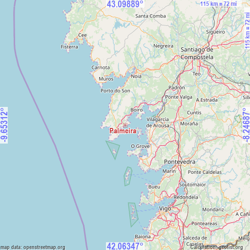
Palmeira GPS coordinates[2]
42° 34' 59.988" North, 8° 57' 0" West
| Map corner | latitude | longitude |
|---|---|---|
| Upper-left | 43.09889°, | -9.65312° |
| Center: | 42.58333°, | -8.95° |
| Lower-right: | 42.06347°, | -8.24687° |
| Map W x H: | 115.1×115.1 km | = 71.5×71.5mi |
| max Lat: | 43.74134° ⇑10.9% North |
| Palmeira: | 42.58333° |
| min Lat: | ⇓89.1% South 27.64134° |
| min Long | Palmeira | max Long |
| -18.00367° | -8.95° | 4.2899° |
| W 1.8%⇐ | ⇒98.2% E |
Elevation
Elevation of Palmeira is 30 m = 98 ft, and this is 568 m = 1864 ft below average elevation for this country.
| Max E: |
1682 m = 5518 ft | 94.1% |
| Avg. | 598 m = 1962 ft | |
| Palmeira | 30 m = 98 ft | |
Min E: |
0 m = 0 ft | 5.9% |
See also: Spain elevation on elevation.city.
Geographical zone
Palmeira is located in North temperate zone (between Tropic of Cancer and the Arctic Circle). Distance of this Northern Tropic circle is 2128.9 km =1322.8 mi to South.| Distance of | km | miles | from Palmeira |
|---|---|---|---|
| North Pole | 5272.2 | 3276 | to North |
| Arctic Circle | 2666.4 | 1656.8 | to North |
| Tropic Cancer | 2128.9 | 1322.8 | to South |
| Equator | 4734.8 | 2942.1 | to South |


Nearby cities:
15 places around Palmeira: (largest is in red/bold)
• A Pobra do Caramiñal
2.4 km =1.5 mi,  23°
23°
• Boiro
8.9 km =5.5 mi,  36°
36°
• Cambados
13.7 km =8.5 mi,  125°
125°
• Illa de Arousa
6.7 km =4.2 mi,  108°
108°
• Meis
18.8 km =11.7 mi,  119°
119°
• O Grove
12.1 km =7.5 mi,  144°
144°
• Oleiros
4.5 km =2.8 mi,  294°
294°
• Porto do Son
16.4 km =10.2 mi,  343°
343°
• Rianxo
13.1 km =8.1 mi,  55°
55°
• Ribadumia
18 km =11.2 mi, 114°
• Santa Uxía de Ribeira
4.7 km =2.9 mi,  225°
225°
• Sobradelo
13.6 km =8.5 mi,  90°
90°
• Vilagarcía de Arousa
15.3 km =9.5 mi,  84°
84°
• Vilanova de Arousa
10.2 km =6.3 mi,  102°
102°
• Vilaxoán
12.8 km =8 mi, 89°
Sources, notices
• [Note1] Compared only with cities in Spain existing in our database
• [Src1] Map data: © OpenStreetMap contributors (CC-BY-SA)
• [Src2] Other city data from geonames.org with taken over terms of usage.
• [Src3] Geographical zone / Annual Mean Temperature by Robert A. Rohde @ Wikipedia
