Buitrago geodata
Buitrago (Castille and León) is a seat of a third-order administrative division; located in Spain in Europe/Madrid (GMT+2) time zone. With population of 55 people, there are 6410 cities with bigger population in this country. Compared to other cities in Spain, 69.7% of cities are located further ↓South; 62.2% of cities are located further ←West and 90.2% of cities have lower elevation than Buitrago. Note1
Administrative division(s):
- Level 1: Castille and León
- Level 2: Provincia de Soria
- Level 3: Buitrago


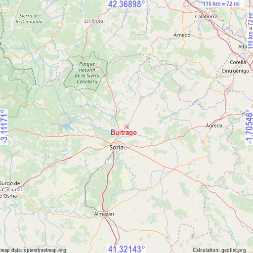
Buitrago GPS coordinates[2]
41° 50' 50.46" North, 2° 24' 30.888" West
| Map corner | latitude | longitude |
|---|---|---|
| Upper-left | 42.36898°, | -3.11171° |
| Center: | 41.84735°, | -2.40858° |
| Lower-right: | 41.32143°, | -1.70546° |
| Map W x H: | 116.5×116.5 km | = 72.4×72.4mi |
| max Lat: | 43.74134° ⇑30.3% North |
| Buitrago: | 41.84735° |
| min Lat: | ⇓69.7% South 27.64134° |
| min Long | Buitrago | max Long |
| -18.00367° | -2.40858° | 4.2899° |
| W 62.2%⇐ | ⇒37.8% E |
Elevation
Elevation of Buitrago is 1034 m = 3392 ft, and this is 436 m = 1430 ft above average elevation for this country.
| Max E: |
1682 m = 5518 ft | 9.8% |
| Buitrago | 1034 m 3392 ft | |
| Avg. | 598 m = 1962 ft | |
Min E: |
0 m = 0 ft | 90.2% |
See also: Spain elevation on elevation.city.
Geographical zone
Buitrago is located in North temperate zone (between Tropic of Cancer and the Arctic Circle). Distance of this Northern Tropic circle is 2047.1 km =1272 mi to South.| Distance of | km | miles | from Buitrago |
|---|---|---|---|
| North Pole | 5354.1 | 3326.9 | to North |
| Arctic Circle | 2748.2 | 1707.7 | to North |
| Tropic Cancer | 2047.1 | 1272 | to South |
| Equator | 4653 | 2891.2 | to South |


Nearby cities:
15 places around Buitrago: (largest is in red/bold)
• Aldealseñor
8.5 km =5.3 mi,  65°
65°
• Almajano
5.8 km =3.6 mi,  86°
86°
• Arancón
11.8 km =7.3 mi,  116°
116°
• Arévalo de la Sierra
11.1 km =6.9 mi,  3°
3°
• Ausejo de la Sierra
6 km =3.7 mi,  28°
28°
• Carrascosa de la Sierra
11.9 km =7.4 mi,  63°
63°
• Castilfrío de la Sierra
11.7 km =7.3 mi,  46°
46°
• Cirujales del Río
7.2 km =4.5 mi, 72°
• Estepa de San Juan
10.8 km =6.7 mi,  35°
35°
• Fuentecantos
1.7 km =1.1 mi,  277°
277°
• Fuentelsaz de Soria
2.1 km =1.3 mi,  344°
344°
• Garray
4.6 km =2.9 mi,  221°
221°
• Narros
9.4 km =5.8 mi, 88°
• Renieblas
4.3 km =2.7 mi,  135°
135°
• Soria
10.5 km =6.5 mi,  208°
208°
Sources, notices
• [Note1] Compared only with cities in Spain existing in our database
• [Src1] Map data: © OpenStreetMap contributors (CC-BY-SA)
• [Src2] Other city data from geonames.org with taken over terms of usage.
• [Src3] Geographical zone / Annual Mean Temperature by Robert A. Rohde @ Wikipedia
