Fuentelsaz de Soria geodata
Fuentelsaz de Soria (Castille and León) is a seat of a third-order administrative division; located in Spain in Europe/Madrid (GMT+2) time zone. With population of 50 people, there are 6463 cities with bigger population in this country. Compared to other cities in Spain, 70.1% of cities are located further ↓South; 62.1% of cities are located further ←West and 92.4% of cities have lower elevation than Fuentelsaz de Soria. Note1
Administrative division(s):
- Level 1: Castille and León
- Level 2: Provincia de Soria
- Level 3: Fuentelsaz de Soria


Fuentelsaz de Soria GPS coordinates[2]
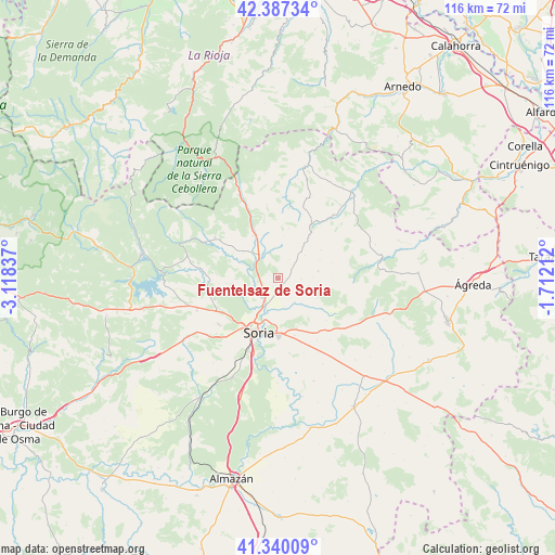
41° 51' 57.096" North, 2° 24' 54.9" West
| Map corner | latitude | longitude |
|---|---|---|
| Upper-left | 42.38734°, | -3.11837° |
| Center: | 41.86586°, | -2.41525° |
| Lower-right: | 41.34009°, | -1.71212° |
| Map W x H: | 116.4×116.4 km | = 72.3×72.3mi |
| max Lat: | 43.74134° ⇑29.9% North |
| Fuentelsaz de Soria: | 41.86586° |
| min Lat: | ⇓70.1% South 27.64134° |
| min Long | Fuentelsaz de S | max Long |
| -18.00367° | -2.41525° | 4.2899° |
| W 62.1%⇐ | ⇒37.9% E |
Elevation
Elevation of Fuentelsaz de Soria is 1079 m = 3540 ft, and this is 481 m = 1578 ft above average elevation for this country.
| Max E: |
1682 m = 5518 ft | 7.6% |
| Fuentelsaz de Soria | 1079 m 3540 ft | |
| Avg. | 598 m = 1962 ft | |
Min E: |
0 m = 0 ft | 92.4% |
See also: Spain elevation on elevation.city.
Geographical zone
Fuentelsaz de Soria is located in North temperate zone (between Tropic of Cancer and the Arctic Circle). Distance of this Northern Tropic circle is 2049.1 km =1273.3 mi to South.| Distance of | km | miles | from Fuentelsaz de Soria |
|---|---|---|---|
| North Pole | 5352 | 3325.6 | to North |
| Arctic Circle | 2746.1 | 1706.3 | to North |
| Tropic Cancer | 2049.1 | 1273.3 | to South |
| Equator | 4655 | 2892.5 | to South |


Nearby cities:
15 places around Fuentelsaz de Soria: (largest is in red/bold)
• Aldealseñor
8.4 km =5.2 mi,  80°
80°
• Almajano
6.6 km =4.1 mi,  104°
104°
• Almarza
10 km =6.2 mi,  333°
333°
• Arévalo de la Sierra
9.1 km =5.7 mi,  7°
7°
• Ausejo de la Sierra
4.7 km =2.9 mi,  46°
46°
• Buitrago
2.1 km =1.3 mi,  164°
164°
• Carrascosa de la Sierra
11.7 km =7.3 mi,  73°
73°
• Castilfrío de la Sierra
10.9 km =6.8 mi,  56°
56°
• Cirujales del Río
7.4 km =4.6 mi,  89°
89°
• Estepa de San Juan
9.6 km =6 mi, 45°
• Fuentecantos
2.1 km =1.3 mi,  210°
210°
• Garray
6.1 km =3.8 mi,  204°
204°
• Narros
10.1 km =6.3 mi, 100°
• Renieblas
6.2 km =3.9 mi,  145°
145°
• Rollamienta
11.7 km =7.3 mi,  304°
304°
Sources, notices
• [Note1] Compared only with cities in Spain existing in our database
• [Src1] Map data: © OpenStreetMap contributors (CC-BY-SA)
• [Src2] Other city data from geonames.org with taken over terms of usage.
• [Src3] Geographical zone / Annual Mean Temperature by Robert A. Rohde @ Wikipedia
