Garray geodata
Garray (Castille and León) is a seat of a third-order administrative division; located in Spain in Europe/Madrid (GMT+2) time zone. With population of 506 people, there are 3868 cities with bigger population in this country. Compared to other cities in Spain, 68.9% of cities are located further ↓South; 61.6% of cities are located further ←West and 89.1% of cities have lower elevation than Garray. Note1


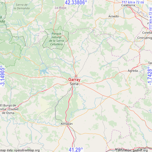
Garray GPS coordinates[2]
41° 48' 58.212" North, 2° 26' 45.312" West
| Map corner | latitude | longitude |
|---|---|---|
| Upper-left | 42.33806°, | -3.14905° |
| Center: | 41.81617°, | -2.44592° |
| Lower-right: | 41.29°, | -1.7428° |
| Map W x H: | 116.5×116.5 km | = 72.4×72.4mi |
| max Lat: | 43.74134° ⇑31.1% North |
| Garray: | 41.81617° |
| min Lat: | ⇓68.9% South 27.64134° |
| min Long | Garray | max Long |
| -18.00367° | -2.44592° | 4.2899° |
| W 61.6%⇐ | ⇒38.4% E |
Elevation
Elevation of Garray is 1018 m = 3340 ft, and this is 420 m = 1378 ft above average elevation for this country.
| Max E: |
1682 m = 5518 ft | 10.9% |
| Garray | 1018 m 3340 ft | |
| Avg. | 598 m = 1962 ft | |
Min E: |
0 m = 0 ft | 89.1% |
See also: Spain elevation on elevation.city.
Geographical zone
Garray is located in North temperate zone (between Tropic of Cancer and the Arctic Circle). Distance of this Northern Tropic circle is 2043.6 km =1269.8 mi to South.| Distance of | km | miles | from Garray |
|---|---|---|---|
| North Pole | 5357.5 | 3329 | to North |
| Arctic Circle | 2751.7 | 1709.8 | to North |
| Tropic Cancer | 2043.6 | 1269.8 | to South |
| Equator | 4649.5 | 2889.1 | to South |


Nearby cities:
15 places around Garray: (largest is in red/bold)
• Alconaba
11.5 km =7.1 mi,  153°
153°
• Aldealseñor
12.8 km =8 mi,  57°
57°
• Almajano
9.7 km =6 mi,  66°
66°
• Almarza
14.6 km =9.1 mi,  352°
352°
• Arancón
13.7 km =8.5 mi,  97°
97°
• Ausejo de la Sierra
10.6 km =6.6 mi,  34°
34°
• Buitrago
4.6 km =2.9 mi,  41°
41°
• Cirujales del Río
11.5 km =7.1 mi, 60°
• Fuentecantos
4 km =2.5 mi,  21°
21°
• Fuentelsaz de Soria
6.1 km =3.8 mi, 24°
• Golmayo
8.4 km =5.2 mi,  228°
228°
• Narros
13.1 km =8.1 mi, 73°
• Renieblas
6.1 km =3.8 mi,  85°
85°
• Rollamienta
14.1 km =8.8 mi,  329°
329°
• Soria
6.1 km =3.8 mi,  198°
198°
Sources, notices
• [Note1] Compared only with cities in Spain existing in our database
• [Src1] Map data: © OpenStreetMap contributors (CC-BY-SA)
• [Src2] Other city data from geonames.org with taken over terms of usage.
• [Src3] Geographical zone / Annual Mean Temperature by Robert A. Rohde @ Wikipedia
