Soria geodata
Soria (Castille and León) is a seat of a second-order administrative division; located in Spain in Europe/Madrid (GMT+2) time zone. With population of 39,528 people, there are 224 cities with bigger population in this country. Compared to other cities in Spain, 67.7% of cities are located further ↓South; 61.4% of cities are located further ←West and 91.8% of cities have lower elevation than Soria. Note1


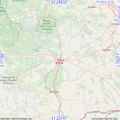
Soria GPS coordinates[2]
41° 45' 50.436" North, 2° 28' 7.788" West
| Map corner | latitude | longitude |
|---|---|---|
| Upper-left | 42.28632°, | -3.17196° |
| Center: | 41.76401°, | -2.46883° |
| Lower-right: | 41.23741°, | -1.76571° |
| Map W x H: | 116.6×116.6 km | = 72.5×72.5mi |
| max Lat: | 43.74134° ⇑32.3% North |
| Soria: | 41.76401° |
| min Lat: | ⇓67.7% South 27.64134° |
| min Long | Soria | max Long |
| -18.00367° | -2.46883° | 4.2899° |
| W 61.4%⇐ | ⇒38.6% E |
Elevation
Elevation of Soria is 1064 m = 3491 ft, and this is 466 m = 1529 ft above average elevation for this country.
| Max E: |
1682 m = 5518 ft | 8.2% |
| Soria | 1064 m 3491 ft | |
| Avg. | 598 m = 1962 ft | |
Min E: |
0 m = 0 ft | 91.8% |
See also: Spain elevation on elevation.city.
Geographical zone
Soria is located in North temperate zone (between Tropic of Cancer and the Arctic Circle). Distance of this Northern Tropic circle is 2037.8 km =1266.2 mi to South.| Distance of | km | miles | from Soria |
|---|---|---|---|
| North Pole | 5363.3 | 3332.6 | to North |
| Arctic Circle | 2757.5 | 1713.4 | to North |
| Tropic Cancer | 2037.8 | 1266.2 | to South |
| Equator | 4643.7 | 2885.5 | to South |


Nearby cities:
15 places around Soria: (largest is in red/bold)
• Alconaba
8.3 km =5.2 mi,  122°
122°
• Aldealafuente
15.7 km =9.8 mi,  130°
130°
• Almajano
14.5 km =9 mi,  48°
48°
• Arancón
16.1 km =10 mi,  75°
75°
• Ausejo de la Sierra
16.5 km =10.3 mi,  28°
28°
• Buitrago
10.5 km =6.5 mi, 28°
• Candilichera
15.4 km =9.6 mi, 115°
• Cidones
15.3 km =9.5 mi,  291°
291°
• Cirujales del Río
16.5 km =10.3 mi, 46°
• Fuentecantos
10.1 km =6.3 mi,  19°
19°
• Fuentelsaz de Soria
12.2 km =7.6 mi, 21°
• Garray
6.1 km =3.8 mi, 18°
• Golmayo
4.5 km =2.8 mi,  273°
273°
• Renieblas
10.1 km =6.3 mi, 52°
• Villaciervos
13.1 km =8.1 mi, 269°
Sources, notices
• [Note1] Compared only with cities in Spain existing in our database
• [Src1] Map data: © OpenStreetMap contributors (CC-BY-SA)
• [Src2] Other city data from geonames.org with taken over terms of usage.
• [Src3] Geographical zone / Annual Mean Temperature by Robert A. Rohde @ Wikipedia
