Ambel geodata
Ambel (Aragon) is a seat of a third-order administrative division; located in Spain in Europe/Madrid (GMT+2) time zone. With population of 332 people, there are 4382 cities with bigger population in this country. Compared to other cities in Spain, 68.3% of cities are located further ↓South; 71.9% of cities are located further ←West and 55.6% of cities have higher elevation than Ambel. Note1


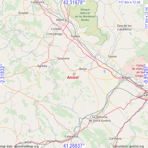
Ambel GPS coordinates[2]
41° 47' 40.992" North, 1° 36' 54.72" West
| Map corner | latitude | longitude |
|---|---|---|
| Upper-left | 42.31678°, | -2.31832° |
| Center: | 41.79472°, | -1.6152° |
| Lower-right: | 41.26837°, | -0.91207° |
| Map W x H: | 116.6×116.6 km | = 72.5×72.5mi |
| max Lat: | 43.74134° ⇑31.7% North |
| Ambel: | 41.79472° |
| min Lat: | ⇓68.3% South 27.64134° |
| min Long | Ambel | max Long |
| -18.00367° | -1.6152° | 4.2899° |
| W 71.9%⇐ | ⇒28.1% E |
Elevation
Elevation of Ambel is 588 m = 1929 ft, and this is 10 m = 33 ft below average elevation for this country.
| Max E: |
1682 m = 5518 ft | 55.6% |
| Avg. | 598 m = 1962 ft | |
| Ambel | 588 m = 1929 ft | |
Min E: |
0 m = 0 ft | 44.4% |
See also: Spain elevation on elevation.city.
Geographical zone
Ambel is located in North temperate zone (between Tropic of Cancer and the Arctic Circle). Distance of this Northern Tropic circle is 2041.2 km =1268.3 mi to South.| Distance of | km | miles | from Ambel |
|---|---|---|---|
| North Pole | 5359.9 | 3330.5 | to North |
| Arctic Circle | 2754 | 1711.3 | to North |
| Tropic Cancer | 2041.2 | 1268.3 | to South |
| Equator | 4647.1 | 2887.6 | to South |


Nearby cities:
15 places around Ambel: (largest is in red/bold)
• Ainzón
8.3 km =5.2 mi,  72°
72°
• Alberite de San Juan
12.3 km =7.6 mi,  76°
76°
• Albeta
10.2 km =6.3 mi, 69°
• Alcalá de Moncayo
6.7 km =4.2 mi,  261°
261°
• Borja
8.1 km =5 mi,  57°
57°
• Bulbuente
3 km =1.9 mi,  20°
20°
• Bureta
10.8 km =6.7 mi, 77°
• Fuendejalón
12.5 km =7.8 mi,  107°
107°
• Grisel
12.6 km =7.8 mi,  312°
312°
• Litago
11.6 km =7.2 mi,  280°
280°
• Maleján
6.6 km =4.1 mi, 56°
• Tabuenca
12.6 km =7.8 mi,  151°
151°
• Talamantes
8.9 km =5.5 mi,  216°
216°
• Trasmoz
9.6 km =6 mi,  291°
291°
• Vera de Moncayo
6.9 km =4.3 mi,  298°
298°
Sources, notices
• [Note1] Compared only with cities in Spain existing in our database
• [Src1] Map data: © OpenStreetMap contributors (CC-BY-SA)
• [Src2] Other city data from geonames.org with taken over terms of usage.
• [Src3] Geographical zone / Annual Mean Temperature by Robert A. Rohde @ Wikipedia
