Ambía geodata
Ambía (Galicia) is a populated place; located in Spain in Europe/Madrid (GMT+2) time zone. With population of 1,885 people, there are 2243 cities with bigger population in this country. Compared to other cities in Spain, 79.4% of cities are located further ↓South; 95.8% of cities are located further →East and 59.5% of cities have higher elevation than Ambía. Note1
Administrative division(s):
- Level 1: Galicia
- Level 2: Provincia de Ourense
- Level 3: Xunqueira de Ambía


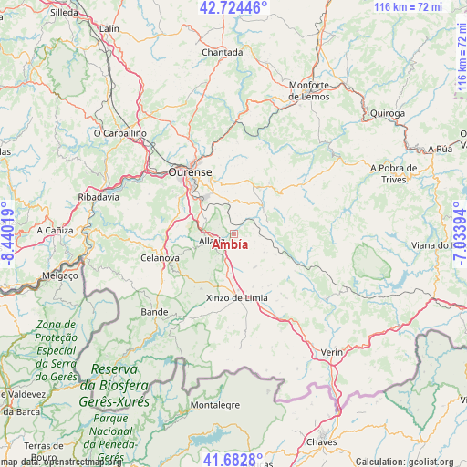
Ambía GPS coordinates[2]
42° 12' 20.808" North, 7° 44' 13.452" West
| Map corner | latitude | longitude |
|---|---|---|
| Upper-left | 42.72446°, | -8.44019° |
| Center: | 42.20578°, | -7.73707° |
| Lower-right: | 41.6828°, | -7.03394° |
| Map W x H: | 115.8×115.8 km | = 72×72mi |
| max Lat: | 43.74134° ⇑20.6% North |
| Ambía: | 42.20578° |
| min Lat: | ⇓79.4% South 27.64134° |
| min Long | Ambía | max Long |
| -18.00367° | -7.73707° | 4.2899° |
| W 4.2%⇐ | ⇒95.8% E |
Elevation
Elevation of Ambía is 533 m = 1749 ft, and this is 65 m = 213 ft below average elevation for this country.
| Max E: |
1682 m = 5518 ft | 59.5% |
| Avg. | 598 m = 1962 ft | |
| Ambía | 533 m = 1749 ft | |
Min E: |
0 m = 0 ft | 40.5% |
See also: Spain elevation on elevation.city.
Geographical zone
Ambía is located in North temperate zone (between Tropic of Cancer and the Arctic Circle). Distance of this Northern Tropic circle is 2086.9 km =1296.7 mi to South.| Distance of | km | miles | from Ambía |
|---|---|---|---|
| North Pole | 5314.2 | 3302.1 | to North |
| Arctic Circle | 2708.3 | 1682.9 | to North |
| Tropic Cancer | 2086.9 | 1296.7 | to South |
| Equator | 4692.8 | 2916 | to South |


Nearby cities:
15 places around Ambía: (largest is in red/bold)
• Allariz
5.6 km =3.5 mi,  252°
252°
• Baños de Molgas
6.7 km =4.2 mi,  53°
53°
• Celanova
18.9 km =11.7 mi, 251°
• Esgos
13.7 km =8.5 mi,  13°
13°
• Luintra
22.7 km =14.1 mi,  2°
2°
• Maceda
10.1 km =6.3 mi, 45°
• Montederramo
20.9 km =13 mi,  68°
68°
• Ourense
17.9 km =11.1 mi,  324°
324°
• Pereiro de Aguiar
16.4 km =10.2 mi,  341°
341°
• Rairiz de Veiga
15.8 km =9.8 mi,  210°
210°
• Sarreaus
17.1 km =10.6 mi,  139°
139°
• Taboadela
8.5 km =5.3 mi,  298°
298°
• Toén
21.8 km =13.5 mi, 304°
• Trasmiras
22.4 km =13.9 mi,  153°
153°
• Xinzo de Limia
15.9 km =9.9 mi,  176°
176°
Sources, notices
• [Note1] Compared only with cities in Spain existing in our database
• [Src1] Map data: © OpenStreetMap contributors (CC-BY-SA)
• [Src2] Other city data from geonames.org with taken over terms of usage.
• [Src3] Geographical zone / Annual Mean Temperature by Robert A. Rohde @ Wikipedia
