Bailo geodata
Bailo (Aragon) is a seat of a third-order administrative division; located in Spain in Europe/Madrid (GMT+2) time zone. With population of 243 people, there are 4788 cities with bigger population in this country. Compared to other cities in Spain, 87.4% of cities are located further ↓South; 78.6% of cities are located further ←West and 56.8% of cities have lower elevation than Bailo. Note1


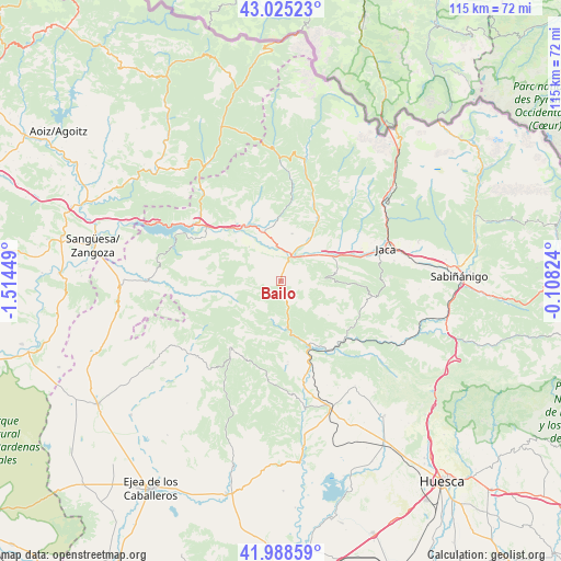
Bailo GPS coordinates[2]
42° 30' 32.616" North, 0° 48' 40.896" West
| Map corner | latitude | longitude |
|---|---|---|
| Upper-left | 43.02523°, | -1.51449° |
| Center: | 42.50906°, | -0.81136° |
| Lower-right: | 41.98859°, | -0.10824° |
| Map W x H: | 115.3×115.3 km | = 71.6×71.6mi |
| max Lat: | 43.74134° ⇑12.6% North |
| Bailo: | 42.50906° |
| min Lat: | ⇓87.4% South 27.64134° |
| min Long | Bailo | max Long |
| -18.00367° | -0.81136° | 4.2899° |
| W 78.6%⇐ | ⇒21.4% E |
Elevation
Elevation of Bailo is 722 m = 2369 ft, and this is 124 m = 407 ft above average elevation for this country.
| Max E: |
1682 m = 5518 ft | 43.2% |
| Bailo | 722 m 2369 ft | |
| Avg. | 598 m = 1962 ft | |
Min E: |
0 m = 0 ft | 56.8% |
See also: Spain elevation on elevation.city.
Geographical zone
Bailo is located in North temperate zone (between Tropic of Cancer and the Arctic Circle). Distance of this Northern Tropic circle is 2120.6 km =1317.7 mi to South.| Distance of | km | miles | from Bailo |
|---|---|---|---|
| North Pole | 5280.5 | 3281.1 | to North |
| Arctic Circle | 2674.6 | 1661.9 | to North |
| Tropic Cancer | 2120.6 | 1317.7 | to South |
| Equator | 4726.6 | 2937 | to South |


Nearby cities:
15 places around Bailo: (largest is in red/bold)
• Agüero
17.2 km =10.7 mi,  175°
175°
• Artieda
16.5 km =10.3 mi,  300°
300°
• Bagüés
11.9 km =7.4 mi,  292°
292°
• Biel
17.2 km =10.7 mi,  218°
218°
• Isuerre
20 km =12.4 mi,  263°
263°
• Jaca
22.4 km =13.9 mi,  72°
72°
• Jasa
23.8 km =14.8 mi,  29°
29°
• Lobera de Onsella
17.6 km =10.9 mi, 258°
• Longás
10.5 km =6.5 mi,  252°
252°
• Luesia
23.3 km =14.5 mi,  228°
228°
• Mianos
14.5 km =9 mi,  305°
305°
• Puente la Reina de Jaca
5.9 km =3.7 mi,  19°
19°
• Salvatierra de Esca
23.9 km =14.9 mi,  318°
318°
• Santa Cruz de la Serós
11.3 km =7 mi,  82°
82°
• Sigüés
21.3 km =13.2 mi, 309°
Sources, notices
• [Note1] Compared only with cities in Spain existing in our database
• [Src1] Map data: © OpenStreetMap contributors (CC-BY-SA)
• [Src2] Other city data from geonames.org with taken over terms of usage.
• [Src3] Geographical zone / Annual Mean Temperature by Robert A. Rohde @ Wikipedia
