Jasa geodata
Jasa (Aragon) is a seat of a third-order administrative division; located in Spain in Europe/Madrid (GMT+2) time zone. With population of 138 people, there are 5518 cities with bigger population in this country. Compared to other cities in Spain, 91.4% of cities are located further ↓South; 80.2% of cities are located further ←West and 84.5% of cities have lower elevation than Jasa. Note1


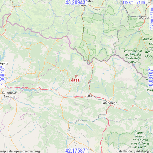
Jasa GPS coordinates[2]
42° 41' 41.28" North, 0° 39' 57.78" West
| Map corner | latitude | longitude |
|---|---|---|
| Upper-left | 43.20943°, | -1.36918° |
| Center: | 42.6948°, | -0.66605° |
| Lower-right: | 42.17587°, | 0.03707° |
| Map W x H: | 114.9×114.9 km | = 71.4×71.4mi |
| max Lat: | 43.74134° ⇑8.6% North |
| Jasa: | 42.6948° |
| min Lat: | ⇓91.4% South 27.64134° |
| min Long | Jasa | max Long |
| -18.00367° | -0.66605° | 4.2899° |
| W 80.2%⇐ | ⇒19.8% E |
Elevation
Elevation of Jasa is 945 m = 3100 ft, and this is 347 m = 1138 ft above average elevation for this country.
| Max E: |
1682 m = 5518 ft | 15.5% |
| Jasa | 945 m 3100 ft | |
| Avg. | 598 m = 1962 ft | |
Min E: |
0 m = 0 ft | 84.5% |
See also: Spain elevation on elevation.city.
Geographical zone
Jasa is located in North temperate zone (between Tropic of Cancer and the Arctic Circle). Distance of this Northern Tropic circle is 2141.3 km =1330.5 mi to South.| Distance of | km | miles | from Jasa |
|---|---|---|---|
| North Pole | 5259.8 | 3268.3 | to North |
| Arctic Circle | 2654 | 1649.1 | to North |
| Tropic Cancer | 2141.3 | 1330.5 | to South |
| Equator | 4747.2 | 2949.8 | to South |


Nearby cities:
15 places around Jasa: (largest is in red/bold)
• Ansó
15.1 km =9.4 mi,  297°
297°
• Aragüés del Puerto
1.3 km =0.8 mi,  345°
345°
• Bailo
23.8 km =14.8 mi,  209°
209°
• Borau
7.5 km =4.7 mi,  122°
122°
• Canfranc
11.7 km =7.3 mi,  78°
78°
• Castiello de Jaca
11.9 km =7.4 mi,  127°
127°
• Echo
8.4 km =5.2 mi,  305°
305°
• Fago
18.1 km =11.2 mi,  284°
284°
• Garde
23.7 km =14.7 mi, 296°
• Jaca
16.9 km =10.5 mi,  145°
145°
• Mianos
26.6 km =16.5 mi,  242°
242°
• Puente la Reina de Jaca
18.1 km =11.2 mi, 213°
• Santa Cruz de la Serós
19.1 km =11.9 mi,  182°
182°
• Urzainqui
27.4 km =17 mi, 303°
• Villanúa
10.6 km =6.6 mi,  99°
99°
Sources, notices
• [Note1] Compared only with cities in Spain existing in our database
• [Src1] Map data: © OpenStreetMap contributors (CC-BY-SA)
• [Src2] Other city data from geonames.org with taken over terms of usage.
• [Src3] Geographical zone / Annual Mean Temperature by Robert A. Rohde @ Wikipedia
