Ayegui geodata
Ayegui (Navarre) is a seat of a third-order administrative division; located in Spain in Europe/Madrid (GMT+2) time zone. With population of 1,315 people, there are 2625 cities with bigger population in this country. Compared to other cities in Spain, 90.8% of cities are located further ↓South; 67% of cities are located further ←West and 62.5% of cities have higher elevation than Ayegui. Note1


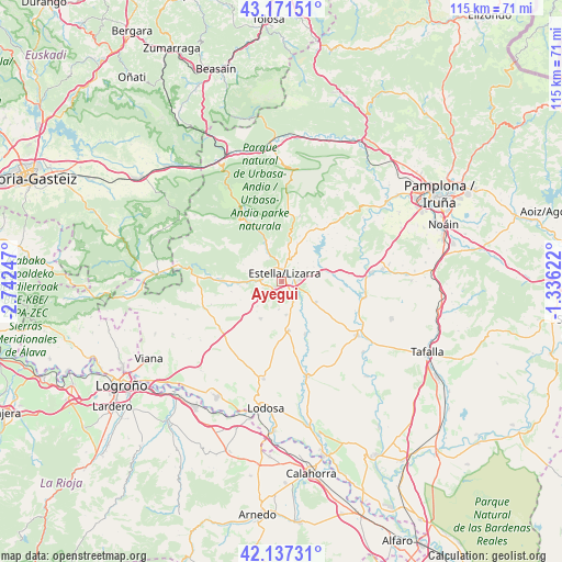
Ayegui GPS coordinates[2]
42° 39' 23.616" North, 2° 2' 21.624" West
| Map corner | latitude | longitude |
|---|---|---|
| Upper-left | 43.17151°, | -2.74247° |
| Center: | 42.65656°, | -2.03934° |
| Lower-right: | 42.13731°, | -1.33622° |
| Map W x H: | 115×115 km | = 71.5×71.5mi |
| max Lat: | 43.74134° ⇑9.2% North |
| Ayegui: | 42.65656° |
| min Lat: | ⇓90.8% South 27.64134° |
| min Long | Ayegui | max Long |
| -18.00367° | -2.03934° | 4.2899° |
| W 67%⇐ | ⇒33% E |
Elevation
Elevation of Ayegui is 493 m = 1617 ft, and this is 105 m = 344 ft below average elevation for this country.
| Max E: |
1682 m = 5518 ft | 62.5% |
| Avg. | 598 m = 1962 ft | |
| Ayegui | 493 m = 1617 ft | |
Min E: |
0 m = 0 ft | 37.5% |
See also: Spain elevation on elevation.city.
Geographical zone
Ayegui is located in North temperate zone (between Tropic of Cancer and the Arctic Circle). Distance of this Northern Tropic circle is 2137 km =1327.9 mi to South.| Distance of | km | miles | from Ayegui |
|---|---|---|---|
| North Pole | 5264.1 | 3271 | to North |
| Arctic Circle | 2658.2 | 1651.7 | to North |
| Tropic Cancer | 2137 | 1327.9 | to South |
| Equator | 4743 | 2947.2 | to South |


Nearby cities:
15 places around Ayegui: (largest is in red/bold)
• Abáigar
8.4 km =5.2 mi,  263°
263°
• Abárzuza
8 km =5 mi,  9°
9°
• Arellano
5.7 km =3.5 mi,  185°
185°
• Arróniz
8.7 km =5.4 mi,  209°
209°
• Dicastillo
6.8 km =4.2 mi,  171°
171°
• Estella-Lizarra
1.8 km =1.1 mi,  18°
18°
• Igúzquiza
4 km =2.5 mi,  251°
251°
• Metauten
7.8 km =4.8 mi,  287°
287°
• Morentin
5.3 km =3.3 mi,  156°
156°
• Murieta
9.4 km =5.8 mi,  269°
269°
• Olejua
9.2 km =5.7 mi, 246°
• Oteiza
8.1 km =5 mi,  120°
120°
• Villamayor de Monjardín
6.2 km =3.9 mi,  240°
240°
• Villatuerta
3.9 km =2.4 mi,  83°
83°
• Yerri
9.7 km =6 mi,  58°
58°
Sources, notices
• [Note1] Compared only with cities in Spain existing in our database
• [Src1] Map data: © OpenStreetMap contributors (CC-BY-SA)
• [Src2] Other city data from geonames.org with taken over terms of usage.
• [Src3] Geographical zone / Annual Mean Temperature by Robert A. Rohde @ Wikipedia
