Metauten geodata
Metauten (Navarre) is a seat of a third-order administrative division; located in Spain in Europe/Madrid (GMT+2) time zone. With population of 297 people, there are 4514 cities with bigger population in this country. Compared to other cities in Spain, 91.2% of cities are located further ↓South; 65.7% of cities are located further ←West and 60% of cities have higher elevation than Metauten. Note1


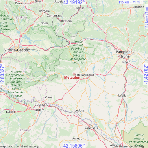
Metauten GPS coordinates[2]
42° 40' 37.704" North, 2° 7' 48.54" West
| Map corner | latitude | longitude |
|---|---|---|
| Upper-left | 43.19192°, | -2.83327° |
| Center: | 42.67714°, | -2.13015° |
| Lower-right: | 42.15806°, | -1.42702° |
| Map W x H: | 115×115 km | = 71.5×71.5mi |
| max Lat: | 43.74134° ⇑8.8% North |
| Metauten: | 42.67714° |
| min Lat: | ⇓91.2% South 27.64134° |
| min Long | Metauten | max Long |
| -18.00367° | -2.13015° | 4.2899° |
| W 65.7%⇐ | ⇒34.3% E |
Elevation
Elevation of Metauten is 527 m = 1729 ft, and this is 71 m = 233 ft below average elevation for this country.
| Max E: |
1682 m = 5518 ft | 60% |
| Avg. | 598 m = 1962 ft | |
| Metauten | 527 m = 1729 ft | |
Min E: |
0 m = 0 ft | 40% |
See also: Spain elevation on elevation.city.
Geographical zone
Metauten is located in North temperate zone (between Tropic of Cancer and the Arctic Circle). Distance of this Northern Tropic circle is 2139.3 km =1329.3 mi to South.| Distance of | km | miles | from Metauten |
|---|---|---|---|
| North Pole | 5261.8 | 3269.5 | to North |
| Arctic Circle | 2655.9 | 1650.3 | to North |
| Tropic Cancer | 2139.3 | 1329.3 | to South |
| Equator | 4745.3 | 2948.6 | to South |


Nearby cities:
15 places around Metauten: (largest is in red/bold)
• Abáigar
3.4 km =2.1 mi,  196°
196°
• Abárzuza
10.4 km =6.5 mi,  57°
57°
• Ancín
5.1 km =3.2 mi,  248°
248°
• Arróniz
10.4 km =6.5 mi,  162°
162°
• Ayegui
7.8 km =4.8 mi,  107°
107°
• Estella-Lizarra
8 km =5 mi,  94°
94°
• Etayo
7 km =4.3 mi, 196°
• Igúzquiza
5.1 km =3.2 mi,  133°
133°
• Legaria
4.7 km =2.9 mi,  229°
229°
• Murieta
3.1 km =1.9 mi,  220°
220°
• Oco
5.2 km =3.2 mi,  213°
213°
• Olejua
6.1 km =3.8 mi,  189°
189°
• Piedramillera
7.9 km =4.9 mi, 230°
• Sorlada
9.8 km =6.1 mi, 225°
• Villamayor de Monjardín
5.7 km =3.5 mi, 158°
Sources, notices
• [Note1] Compared only with cities in Spain existing in our database
• [Src1] Map data: © OpenStreetMap contributors (CC-BY-SA)
• [Src2] Other city data from geonames.org with taken over terms of usage.
• [Src3] Geographical zone / Annual Mean Temperature by Robert A. Rohde @ Wikipedia
