Avilés geodata
Avilés (Asturias) is a populated place; located in Spain in Europe/Madrid (GMT+2) time zone. With population of 84,242 people, there are 103 cities with bigger population in this country. Compared to other cities in Spain, 99.8% of cities are located further ↓South; 85.1% of cities are located further →East and 94.7% of cities have higher elevation than Avilés. Note1


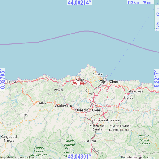
Avilés GPS coordinates[2]
43° 33' 17.028" North, 5° 55' 29.388" West
| Map corner | latitude | longitude |
|---|---|---|
| Upper-left | 44.06214°, | -6.62795° |
| Center: | 43.55473°, | -5.92483° |
| Lower-right: | 43.04301°, | -5.2217° |
| Map W x H: | 113.3×113.3 km | = 70.4×70.4mi |
| max Lat: | 43.74134° ⇑0.2% North |
| Avilés: | 43.55473° |
| min Lat: | ⇓99.8% South 27.64134° |
| min Long | Avilés | max Long |
| -18.00367° | -5.92483° | 4.2899° |
| W 14.9%⇐ | ⇒85.1% E |
Elevation
Elevation of Avilés is 26 m = 85 ft, and this is 572 m = 1877 ft below average elevation for this country.
| Max E: |
1682 m = 5518 ft | 94.7% |
| Avg. | 598 m = 1962 ft | |
| Avilés | 26 m = 85 ft | |
Min E: |
0 m = 0 ft | 5.3% |
See also: Avilés elevation on elevation.city.
Geographical zone
Avilés is located in North temperate zone (between Tropic of Cancer and the Arctic Circle). Distance of this Northern Tropic circle is 2236.9 km =1389.9 mi to South.| Distance of | km | miles | from Avilés |
|---|---|---|---|
| North Pole | 5164.2 | 3208.9 | to North |
| Arctic Circle | 2558.3 | 1589.7 | to North |
| Tropic Cancer | 2236.9 | 1389.9 | to South |
| Equator | 4842.8 | 3009.2 | to South |


Nearby cities:
15 places around Avilés: (largest is in red/bold)
• Castrillón
5.6 km =3.5 mi,  262°
262°
• Corvera de Asturias
3.6 km =2.2 mi,  126°
126°
• Cudillero
17.8 km =11.1 mi,  272°
272°
• Illas
7.6 km =4.7 mi,  212°
212°
• Llanera
10.3 km =6.4 mi,  182°
182°
• Llanera
13.9 km =8.6 mi,  166°
166°
• Luanco
12.5 km =7.8 mi,  57°
57°
• Lugones
19.2 km =11.9 mi,  151°
151°
• Muros de Nalón
14.5 km =9 mi, 264°
• Piedras Blancas
4.1 km =2.5 mi,  276°
276°
• Pravia
16.8 km =10.4 mi,  243°
243°
• Ranón
11.3 km =7 mi, 269°
• San Esteban de Pravia
13.1 km =8.1 mi, 269°
• San Juan de la Arena
12.1 km =7.5 mi, 272°
• Soto del Barco
11.9 km =7.4 mi, 258°
Sources, notices
• [Note1] Compared only with cities in Spain existing in our database
• [Src1] Map data: © OpenStreetMap contributors (CC-BY-SA)
• [Src2] Other city data from geonames.org with taken over terms of usage.
• [Src3] Geographical zone / Annual Mean Temperature by Robert A. Rohde @ Wikipedia
