Llanera geodata
Llanera (Asturias) is a populated place; located in Spain in Europe/Madrid (GMT+2) time zone. With population of 13,776 people, there are 675 cities with bigger population in this country. Compared to other cities in Spain, 99.3% of cities are located further ↓South; 85.2% of cities are located further →East and 78% of cities have higher elevation than Llanera. Note1


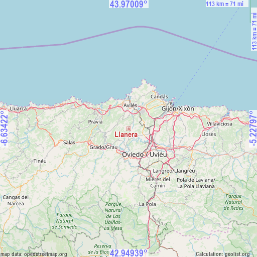
Llanera GPS coordinates[2]
43° 27' 42.804" North, 5° 55' 51.96" West
| Map corner | latitude | longitude |
|---|---|---|
| Upper-left | 43.97009°, | -6.63422° |
| Center: | 43.46189°, | -5.9311° |
| Lower-right: | 42.94939°, | -5.22797° |
| Map W x H: | 113.5×113.5 km | = 70.5×70.5mi |
| max Lat: | 43.74134° ⇑0.7% North |
| Llanera: | 43.46189° |
| min Lat: | ⇓99.3% South 27.64134° |
| min Long | Llanera | max Long |
| -18.00367° | -5.9311° | 4.2899° |
| W 14.8%⇐ | ⇒85.2% E |
Elevation
Elevation of Llanera is 256 m = 840 ft, and this is 342 m = 1122 ft below average elevation for this country.
| Max E: |
1682 m = 5518 ft | 78% |
| Avg. | 598 m = 1962 ft | |
| Llanera | 256 m = 840 ft | |
Min E: |
0 m = 0 ft | 22% |
See also: Spain elevation on elevation.city.
Geographical zone
Llanera is located in North temperate zone (between Tropic of Cancer and the Arctic Circle). Distance of this Northern Tropic circle is 2226.6 km =1383.5 mi to South.| Distance of | km | miles | from Llanera |
|---|---|---|---|
| North Pole | 5174.6 | 3215.3 | to North |
| Arctic Circle | 2568.7 | 1596.1 | to North |
| Tropic Cancer | 2226.6 | 1383.5 | to South |
| Equator | 4832.5 | 3002.8 | to South |


Nearby cities:
15 places around Llanera: (largest is in red/bold)
• Avilés
10.3 km =6.4 mi,  2°
2°
• Castrillón
10.8 km =6.7 mi,  332°
332°
• Corvera de Asturias
8.9 km =5.5 mi,  22°
22°
• Grado
14.2 km =8.8 mi,  234°
234°
• Illas
5.3 km =3.3 mi,  317°
317°
• Llanera
5 km =3.1 mi,  129°
129°
• Lugones
11.6 km =7.2 mi,  124°
124°
• Oviedo
13.3 km =8.3 mi,  148°
148°
• Piedras Blancas
11.4 km =7.1 mi,  341°
341°
• Pravia
14.9 km =9.3 mi,  281°
281°
• Ranón
14.8 km =9.2 mi,  313°
313°
• San Claudio
12.5 km =7.8 mi,  174°
174°
• San Esteban de Pravia
16.2 km =10.1 mi, 309°
• San Juan de la Arena
15.8 km =9.8 mi, 313°
• Soto del Barco
13.7 km =8.5 mi, 305°
Sources, notices
• [Note1] Compared only with cities in Spain existing in our database
• [Src1] Map data: © OpenStreetMap contributors (CC-BY-SA)
• [Src2] Other city data from geonames.org with taken over terms of usage.
• [Src3] Geographical zone / Annual Mean Temperature by Robert A. Rohde @ Wikipedia
