Llanera geodata
Llanera (Asturias) is a seat of a third-order administrative division; located in Spain in Europe/Madrid (GMT+2) time zone. In our database, there are 6762 cities with bigger population. Compared to other cities in Spain, 99.1% of cities are located further ↓South; 84.4% of cities are located further →East and 83.6% of cities have higher elevation than Llanera. Note1


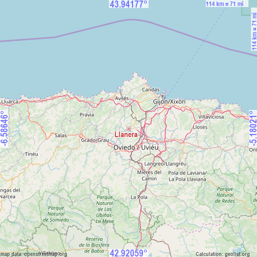
Llanera GPS coordinates[2]
43° 25' 59.988" North, 5° 52' 59.988" West
| Map corner | latitude | longitude |
|---|---|---|
| Upper-left | 43.94177°, | -6.58646° |
| Center: | 43.43333°, | -5.88333° |
| Lower-right: | 42.92059°, | -5.18021° |
| Map W x H: | 113.5×113.5 km | = 70.5×70.5mi |
| max Lat: | 43.74134° ⇑0.9% North |
| Llanera: | 43.43333° |
| min Lat: | ⇓99.1% South 27.64134° |
| min Long | Llanera | max Long |
| -18.00367° | -5.88333° | 4.2899° |
| W 15.6%⇐ | ⇒84.4% E |
Elevation
Elevation of Llanera is 161 m = 528 ft, and this is 437 m = 1434 ft below average elevation for this country.
| Max E: |
1682 m = 5518 ft | 83.6% |
| Avg. | 598 m = 1962 ft | |
| Llanera | 161 m = 528 ft | |
Min E: |
0 m = 0 ft | 16.4% |
See also: Spain elevation on elevation.city.
Geographical zone
Llanera is located in North temperate zone (between Tropic of Cancer and the Arctic Circle). Distance of this Northern Tropic circle is 2223.4 km =1381.6 mi to South.| Distance of | km | miles | from Llanera |
|---|---|---|---|
| North Pole | 5177.7 | 3217.3 | to North |
| Arctic Circle | 2571.8 | 1598 | to North |
| Tropic Cancer | 2223.4 | 1381.6 | to South |
| Equator | 4829.3 | 3000.8 | to South |


Nearby cities:
15 places around Llanera: (largest is in red/bold)
• Avilés
13.9 km =8.6 mi,  346°
346°
• Castandiello
17.1 km =10.6 mi,  182°
182°
• Castrillón
15.5 km =9.6 mi,  325°
325°
• Corvera de Asturias
11.4 km =7.1 mi,  357°
357°
• Grado
16.2 km =10.1 mi,  251°
251°
• Illas
10.3 km =6.4 mi,  313°
313°
• Llanera
5 km =3.1 mi, 309°
• Lugones
6.7 km =4.2 mi,  120°
120°
• Noreña
14.9 km =9.3 mi,  107°
107°
• Oviedo
8.7 km =5.4 mi,  159°
159°
• Piedras Blancas
15.8 km =9.8 mi, 331°
• Pola de Siero
18.3 km =11.4 mi,  104°
104°
• Pravia
19.4 km =12.1 mi,  288°
288°
• San Claudio
9.6 km =6 mi,  196°
196°
• Soto del Barco
18.7 km =11.6 mi, 306°
Sources, notices
• [Note1] Compared only with cities in Spain existing in our database
• [Src1] Map data: © OpenStreetMap contributors (CC-BY-SA)
• [Src2] Other city data from geonames.org with taken over terms of usage.
• [Src3] Geographical zone / Annual Mean Temperature by Robert A. Rohde @ Wikipedia
