Soto del Barco geodata
Soto del Barco (Asturias) is a seat of a third-order administrative division; located in Spain in Europe/Madrid (GMT+2) time zone. With population of 4,108 people, there are 1453 cities with bigger population in this country. Compared to other cities in Spain, 99.5% of cities are located further ↓South; 87% of cities are located further →East and 90.3% of cities have higher elevation than Soto del Barco. Note1


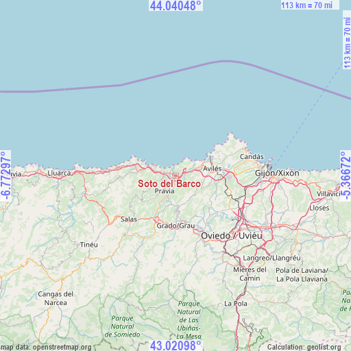
Soto del Barco GPS coordinates[2]
43° 31' 58.368" North, 6° 4' 11.424" West
| Map corner | latitude | longitude |
|---|---|---|
| Upper-left | 44.04048°, | -6.77297° |
| Center: | 43.53288°, | -6.06984° |
| Lower-right: | 43.02098°, | -5.36672° |
| Map W x H: | 113.4×113.4 km | = 70.5×70.5mi |
| max Lat: | 43.74134° ⇑0.5% North |
| Soto del Barco: | 43.53288° |
| min Lat: | ⇓99.5% South 27.64134° |
| min Long | Soto del Barco | max Long |
| -18.00367° | -6.06984° | 4.2899° |
| W 13%⇐ | ⇒87% E |
Elevation
Elevation of Soto del Barco is 61 m = 200 ft, and this is 537 m = 1762 ft below average elevation for this country.
| Max E: |
1682 m = 5518 ft | 90.3% |
| Avg. | 598 m = 1962 ft | |
| Soto del Barco | 61 m = 200 ft | |
Min E: |
0 m = 0 ft | 9.7% |
See also: Spain elevation on elevation.city.
Geographical zone
Soto del Barco is located in North temperate zone (between Tropic of Cancer and the Arctic Circle). Distance of this Northern Tropic circle is 2234.5 km =1388.5 mi to South.| Distance of | km | miles | from Soto del Barco |
|---|---|---|---|
| North Pole | 5166.7 | 3210.4 | to North |
| Arctic Circle | 2560.8 | 1591.2 | to North |
| Tropic Cancer | 2234.5 | 1388.5 | to South |
| Equator | 4840.4 | 3007.7 | to South |


Nearby cities:
15 places around Soto del Barco: (largest is in red/bold)
• Avilés
11.9 km =7.4 mi,  78°
78°
• Castrillón
6.4 km =4 mi,  74°
74°
• Corvera de Asturias
14.6 km =9.1 mi,  88°
88°
• Cudillero
6.9 km =4.3 mi,  297°
297°
• Grado
16.1 km =10 mi,  181°
181°
• Illas
8.6 km =5.3 mi,  117°
117°
• Llanera
13.7 km =8.5 mi,  125°
125°
• Llanera
18.7 km =11.6 mi, 126°
• Muros de Nalón
2.9 km =1.8 mi,  292°
292°
• Piedras Blancas
8.1 km =5 mi, 68°
• Pravia
6 km =3.7 mi,  214°
214°
• Ranón
2.3 km =1.4 mi,  9°
9°
• Salas
20.4 km =12.7 mi,  228°
228°
• San Esteban de Pravia
2.7 km =1.7 mi,  328°
328°
• San Juan de la Arena
2.9 km =1.8 mi,  352°
352°
Sources, notices
• [Note1] Compared only with cities in Spain existing in our database
• [Src1] Map data: © OpenStreetMap contributors (CC-BY-SA)
• [Src2] Other city data from geonames.org with taken over terms of usage.
• [Src3] Geographical zone / Annual Mean Temperature by Robert A. Rohde @ Wikipedia
