Carballo geodata
Carballo (Galicia) is a seat of a third-order administrative division; located in Spain in Europe/Madrid (GMT+2) time zone. With population of 30,990 people, there are 292 cities with bigger population in this country. Compared to other cities in Spain, 96.5% of cities are located further ↓South; 97.6% of cities are located further →East and 86.9% of cities have higher elevation than Carballo. Note1


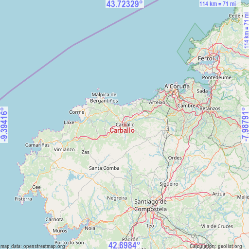
Carballo GPS coordinates[2]
43° 12' 46.8" North, 8° 41' 27.744" West
| Map corner | latitude | longitude |
|---|---|---|
| Upper-left | 43.72329°, | -9.39416° |
| Center: | 43.213°, | -8.69104° |
| Lower-right: | 42.6984°, | -7.98791° |
| Map W x H: | 114×114 km | = 70.8×70.8mi |
| max Lat: | 43.74134° ⇑3.5% North |
| Carballo: | 43.213° |
| min Lat: | ⇓96.5% South 27.64134° |
| min Long | Carballo | max Long |
| -18.00367° | -8.69104° | 4.2899° |
| W 2.4%⇐ | ⇒97.6% E |
Elevation
Elevation of Carballo is 111 m = 364 ft, and this is 487 m = 1598 ft below average elevation for this country.
| Max E: |
1682 m = 5518 ft | 86.9% |
| Avg. | 598 m = 1962 ft | |
| Carballo | 111 m = 364 ft | |
Min E: |
0 m = 0 ft | 13.1% |
See also: Spain elevation on elevation.city.
Geographical zone
Carballo is located in North temperate zone (between Tropic of Cancer and the Arctic Circle). Distance of this Northern Tropic circle is 2198.9 km =1366.3 mi to South.| Distance of | km | miles | from Carballo |
|---|---|---|---|
| North Pole | 5202.2 | 3232.5 | to North |
| Arctic Circle | 2596.3 | 1613.3 | to North |
| Tropic Cancer | 2198.9 | 1366.3 | to South |
| Equator | 4804.8 | 2985.6 | to South |


Nearby cities:
15 places around Carballo: (largest is in red/bold)
• A Baña
28.5 km =17.7 mi,  190°
190°
• Arteixo
18 km =11.2 mi,  55°
55°
• Carral
27.2 km =16.9 mi,  86°
86°
• Cerceda
17.2 km =10.7 mi,  101°
101°
• Coristanco
5 km =3.1 mi,  253°
253°
• Culleredo
25.9 km =16.1 mi,  71°
71°
• Laracha
9.7 km =6 mi, 62°
• Laxe
25.6 km =15.9 mi,  271°
271°
• Malpica
15.6 km =9.7 mi,  321°
321°
• Ordes
27.5 km =17.1 mi,  123°
123°
• Pastoriza
22.6 km =14 mi,  53°
53°
• San Roque
5 km =3.1 mi, 253°
• Santa Comba
22.2 km =13.8 mi,  205°
205°
• Trazo
25.3 km =15.7 mi,  149°
149°
• Zas
22.2 km =13.8 mi,  235°
235°
Sources, notices
• [Note1] Compared only with cities in Spain existing in our database
• [Src1] Map data: © OpenStreetMap contributors (CC-BY-SA)
• [Src2] Other city data from geonames.org with taken over terms of usage.
• [Src3] Geographical zone / Annual Mean Temperature by Robert A. Rohde @ Wikipedia
