Cerceda geodata
Cerceda (Galicia) is a seat of a third-order administrative division; located in Spain in Europe/Madrid (GMT+2) time zone. In our database, there are 6762 cities with bigger population. Compared to other cities in Spain, 96.2% of cities are located further ↓South; 97.3% of cities are located further →East and 71.1% of cities have higher elevation than Cerceda. Note1


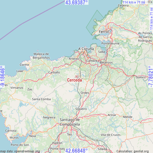
Cerceda GPS coordinates[2]
43° 10' 59.988" North, 8° 28' 59.988" West
| Map corner | latitude | longitude |
|---|---|---|
| Upper-left | 43.69387°, | -9.18646° |
| Center: | 43.18333°, | -8.48333° |
| Lower-right: | 42.66848°, | -7.78021° |
| Map W x H: | 114×114 km | = 70.8×70.8mi |
| max Lat: | 43.74134° ⇑3.8% North |
| Cerceda: | 43.18333° |
| min Lat: | ⇓96.2% South 27.64134° |
| min Long | Cerceda | max Long |
| -18.00367° | -8.48333° | 4.2899° |
| W 2.7%⇐ | ⇒97.3% E |
Elevation
Elevation of Cerceda is 365 m = 1198 ft, and this is 233 m = 764 ft below average elevation for this country.
| Max E: |
1682 m = 5518 ft | 71.1% |
| Avg. | 598 m = 1962 ft | |
| Cerceda | 365 m = 1198 ft | |
Min E: |
0 m = 0 ft | 28.9% |
See also: Spain elevation on elevation.city.
Geographical zone
Cerceda is located in North temperate zone (between Tropic of Cancer and the Arctic Circle). Distance of this Northern Tropic circle is 2195.6 km =1364.3 mi to South.| Distance of | km | miles | from Cerceda |
|---|---|---|---|
| North Pole | 5205.5 | 3234.5 | to North |
| Arctic Circle | 2599.6 | 1615.3 | to North |
| Tropic Cancer | 2195.6 | 1364.3 | to South |
| Equator | 4801.5 | 2983.5 | to South |


Nearby cities:
15 places around Cerceda: (largest is in red/bold)
• Abegondo
16.6 km =10.3 mi,  77°
77°
• Arteixo
13.6 km =8.5 mi,  351°
351°
• Cambre
16.5 km =10.3 mi,  41°
41°
• Carballo
17.2 km =10.7 mi,  281°
281°
• Carral
11.5 km =7.1 mi,  64°
64°
• Coristanco
21.7 km =13.5 mi,  274°
274°
• Culleredo
13.9 km =8.6 mi,  33°
33°
• Frades
21.3 km =13.2 mi,  133°
133°
• Laracha
11.4 km =7.1 mi,  313°
313°
• Mesia
19.9 km =12.4 mi,  117°
117°
• Oleiros
21.5 km =13.4 mi, 38°
• Ordes
13.3 km =8.3 mi,  153°
153°
• Pastoriza
16.7 km =10.4 mi,  4°
4°
• San Roque
21.7 km =13.5 mi, 274°
• Trazo
19 km =11.8 mi,  192°
192°
Sources, notices
• [Note1] Compared only with cities in Spain existing in our database
• [Src1] Map data: © OpenStreetMap contributors (CC-BY-SA)
• [Src2] Other city data from geonames.org with taken over terms of usage.
• [Src3] Geographical zone / Annual Mean Temperature by Robert A. Rohde @ Wikipedia
