Armañanzas geodata
Armañanzas (Navarre) is a seat of a third-order administrative division; located in Spain in Europe/Madrid (GMT+2) time zone. With population of 78 people, there are 6162 cities with bigger population in this country. Compared to other cities in Spain, 88.5% of cities are located further ↓South; 63.6% of cities are located further ←West and 62.4% of cities have higher elevation than Armañanzas. Note1


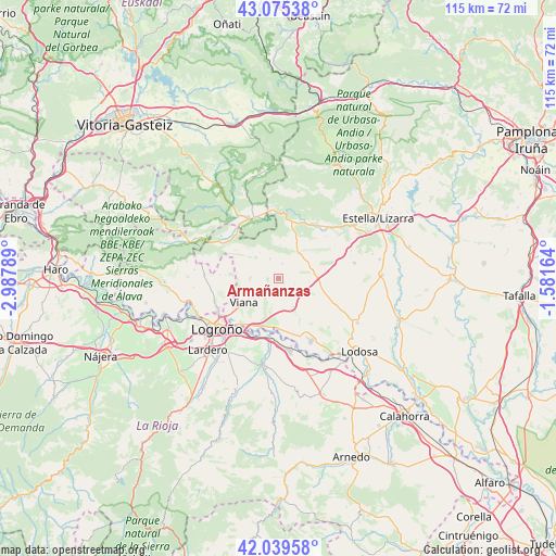
Armañanzas GPS coordinates[2]
42° 33' 34.668" North, 2° 17' 5.136" West
| Map corner | latitude | longitude |
|---|---|---|
| Upper-left | 43.07538°, | -2.98789° |
| Center: | 42.55963°, | -2.28476° |
| Lower-right: | 42.03958°, | -1.58164° |
| Map W x H: | 115.2×115.2 km | = 71.6×71.6mi |
| max Lat: | 43.74134° ⇑11.5% North |
| Armañanzas: | 42.55963° |
| min Lat: | ⇓88.5% South 27.64134° |
| min Long | Armañanzas | max Long |
| -18.00367° | -2.28476° | 4.2899° |
| W 63.6%⇐ | ⇒36.4% E |
Elevation
Elevation of Armañanzas is 494 m = 1621 ft, and this is 104 m = 341 ft below average elevation for this country.
| Max E: |
1682 m = 5518 ft | 62.4% |
| Avg. | 598 m = 1962 ft | |
| Armañanzas | 494 m = 1621 ft | |
Min E: |
0 m = 0 ft | 37.6% |
See also: Spain elevation on elevation.city.
Geographical zone
Armañanzas is located in North temperate zone (between Tropic of Cancer and the Arctic Circle). Distance of this Northern Tropic circle is 2126.3 km =1321.2 mi to South.| Distance of | km | miles | from Armañanzas |
|---|---|---|---|
| North Pole | 5274.9 | 3277.7 | to North |
| Arctic Circle | 2669 | 1658.4 | to North |
| Tropic Cancer | 2126.3 | 1321.2 | to South |
| Equator | 4732.2 | 2940.5 | to South |


Nearby cities:
15 places around Armañanzas: (largest is in red/bold)
• Aguilar de Codés
10.4 km =6.5 mi,  304°
304°
• Aras
5.8 km =3.6 mi,  272°
272°
• Azuelo
7.6 km =4.7 mi,  315°
315°
• Bargota
2.1 km =1.3 mi, 270°
• Desojo
3.3 km =2.1 mi,  15°
15°
• Espronceda
4.5 km =2.8 mi,  338°
338°
• Lazagurría
8.3 km =5.2 mi,  153°
153°
• Los Arcos
7.6 km =4.7 mi,  80°
80°
• Mirafuentes
7.1 km =4.4 mi,  3°
3°
• Nazar
8.6 km =5.3 mi, 2°
• Piedramillera
10.4 km =6.5 mi,  39°
39°
• Sansol
1.6 km =1 mi,  114°
114°
• Sorlada
8.4 km =5.2 mi, 42°
• Torres del Río
1.3 km =0.8 mi,  132°
132°
• Viana
8.6 km =5.3 mi,  235°
235°
Sources, notices
• [Note1] Compared only with cities in Spain existing in our database
• [Src1] Map data: © OpenStreetMap contributors (CC-BY-SA)
• [Src2] Other city data from geonames.org with taken over terms of usage.
• [Src3] Geographical zone / Annual Mean Temperature by Robert A. Rohde @ Wikipedia
