Nazar geodata
Nazar (Navarre) is a seat of a third-order administrative division; located in Spain in Europe/Madrid (GMT+2) time zone. With population of 57 people, there are 6380 cities with bigger population in this country. Compared to other cities in Spain, 90.4% of cities are located further ↓South; 63.7% of cities are located further ←West and 59.9% of cities have lower elevation than Nazar. Note1


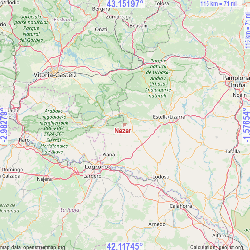
Nazar GPS coordinates[2]
42° 38' 12.696" North, 2° 16' 46.776" West
| Map corner | latitude | longitude |
|---|---|---|
| Upper-left | 43.15197°, | -2.98279° |
| Center: | 42.63686°, | -2.27966° |
| Lower-right: | 42.11745°, | -1.57654° |
| Map W x H: | 115×115 km | = 71.5×71.5mi |
| max Lat: | 43.74134° ⇑9.6% North |
| Nazar: | 42.63686° |
| min Lat: | ⇓90.4% South 27.64134° |
| min Long | Nazar | max Long |
| -18.00367° | -2.27966° | 4.2899° |
| W 63.7%⇐ | ⇒36.3% E |
Elevation
Elevation of Nazar is 744 m = 2441 ft, and this is 146 m = 479 ft above average elevation for this country.
| Max E: |
1682 m = 5518 ft | 40.1% |
| Nazar | 744 m 2441 ft | |
| Avg. | 598 m = 1962 ft | |
Min E: |
0 m = 0 ft | 59.9% |
See also: Spain elevation on elevation.city.
Geographical zone
Nazar is located in North temperate zone (between Tropic of Cancer and the Arctic Circle). Distance of this Northern Tropic circle is 2134.9 km =1326.6 mi to South.| Distance of | km | miles | from Nazar |
|---|---|---|---|
| North Pole | 5266.3 | 3272.3 | to North |
| Arctic Circle | 2660.4 | 1653.1 | to North |
| Tropic Cancer | 2134.9 | 1326.6 | to South |
| Equator | 4740.8 | 2945.8 | to South |


Nearby cities:
15 places around Nazar: (largest is in red/bold)
• Aguilar de Codés
9.4 km =5.8 mi,  253°
253°
• Ancín
7.9 km =4.9 mi,  70°
70°
• Armañanzas
8.6 km =5.3 mi,  182°
182°
• Azuelo
6.6 km =4.1 mi,  241°
241°
• Bargota
8.9 km =5.5 mi,  196°
196°
• Desojo
5.5 km =3.4 mi, 175°
• Espronceda
4.9 km =3 mi,  205°
205°
• Genevilla
9.1 km =5.7 mi,  275°
275°
• Legaria
8.8 km =5.5 mi,  80°
80°
• Mirafuentes
1.5 km =0.9 mi, 180°
• Oco
9.4 km =5.8 mi,  89°
89°
• Piedramillera
6.2 km =3.9 mi,  95°
95°
• Sansol
9.3 km =5.8 mi,  173°
173°
• Sorlada
5.8 km =3.6 mi,  114°
114°
• Zúñiga
6.4 km =4 mi,  345°
345°
Sources, notices
• [Note1] Compared only with cities in Spain existing in our database
• [Src1] Map data: © OpenStreetMap contributors (CC-BY-SA)
• [Src2] Other city data from geonames.org with taken over terms of usage.
• [Src3] Geographical zone / Annual Mean Temperature by Robert A. Rohde @ Wikipedia
