Espronceda geodata
Espronceda (Navarre) is a seat of a third-order administrative division; located in Spain in Europe/Madrid (GMT+2) time zone. With population of 160 people, there are 5341 cities with bigger population in this country. Compared to other cities in Spain, 89.4% of cities are located further ↓South; 63.4% of cities are located further ←West and 59% of cities have higher elevation than Espronceda. Note1


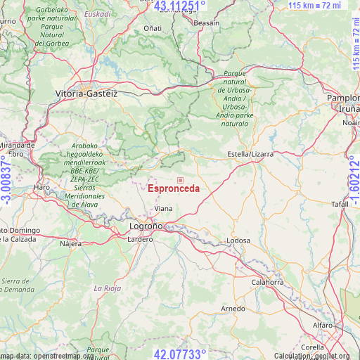
Espronceda GPS coordinates[2]
42° 35' 49.452" North, 2° 18' 18.864" West
| Map corner | latitude | longitude |
|---|---|---|
| Upper-left | 43.11251°, | -3.00837° |
| Center: | 42.59707°, | -2.30524° |
| Lower-right: | 42.07733°, | -1.60212° |
| Map W x H: | 115.1×115.1 km | = 71.5×71.5mi |
| max Lat: | 43.74134° ⇑10.6% North |
| Espronceda: | 42.59707° |
| min Lat: | ⇓89.4% South 27.64134° |
| min Long | Espronceda | max Long |
| -18.00367° | -2.30524° | 4.2899° |
| W 63.4%⇐ | ⇒36.6% E |
Elevation
Elevation of Espronceda is 540 m = 1772 ft, and this is 58 m = 190 ft below average elevation for this country.
| Max E: |
1682 m = 5518 ft | 59% |
| Avg. | 598 m = 1962 ft | |
| Espronceda | 540 m = 1772 ft | |
Min E: |
0 m = 0 ft | 41% |
See also: Spain elevation on elevation.city.
Geographical zone
Espronceda is located in North temperate zone (between Tropic of Cancer and the Arctic Circle). Distance of this Northern Tropic circle is 2130.4 km =1323.8 mi to South.| Distance of | km | miles | from Espronceda |
|---|---|---|---|
| North Pole | 5270.7 | 3275.1 | to North |
| Arctic Circle | 2664.8 | 1655.8 | to North |
| Tropic Cancer | 2130.4 | 1323.8 | to South |
| Equator | 4736.4 | 2943.1 | to South |


Nearby cities:
15 places around Espronceda: (largest is in red/bold)
• Aguilar de Codés
7.1 km =4.4 mi,  283°
283°
• Aras
5.7 km =3.5 mi,  226°
226°
• Armañanzas
4.5 km =2.8 mi,  158°
158°
• Azuelo
3.9 km =2.4 mi,  289°
289°
• Bargota
4.2 km =2.6 mi,  186°
186°
• Cabredo
9.4 km =5.8 mi, 292°
• Desojo
2.7 km =1.7 mi,  111°
111°
• Genevilla
8.8 km =5.5 mi,  307°
307°
• Los Arcos
9.7 km =6 mi, 107°
• Mirafuentes
3.6 km =2.2 mi,  36°
36°
• Nazar
4.9 km =3 mi,  25°
25°
• Piedramillera
9.1 km =5.7 mi,  64°
64°
• Sansol
5.8 km =3.6 mi,  146°
146°
• Sorlada
7.6 km =4.7 mi,  74°
74°
• Torres del Río
5.7 km =3.5 mi, 152°
Sources, notices
• [Note1] Compared only with cities in Spain existing in our database
• [Src1] Map data: © OpenStreetMap contributors (CC-BY-SA)
• [Src2] Other city data from geonames.org with taken over terms of usage.
• [Src3] Geographical zone / Annual Mean Temperature by Robert A. Rohde @ Wikipedia
