Quintanapalla geodata
Quintanapalla (Castille and León) is a seat of a third-order administrative division; located in Spain in Europe/Madrid (GMT+2) time zone. With population of 116 people, there are 5741 cities with bigger population in this country. Compared to other cities in Spain, 85.1% of cities are located further ↓South; 52.7% of cities are located further →East and 82.7% of cities have lower elevation than Quintanapalla. Note1
Administrative division(s):
- Level 1: Castille and León
- Level 2: Provincia de Burgos
- Level 3: Quintanapalla


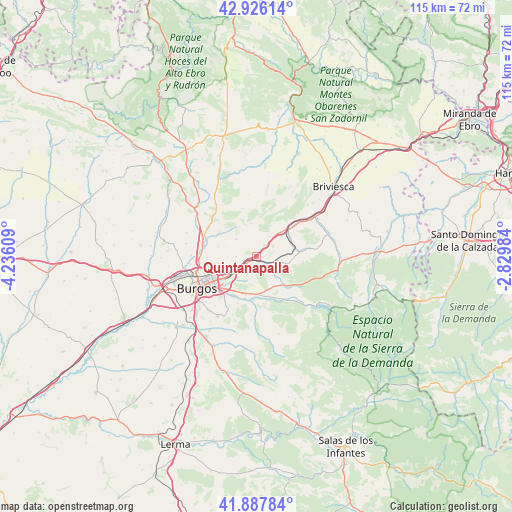
Quintanapalla GPS coordinates[2]
42° 24' 32.904" North, 3° 31' 58.656" West
| Map corner | latitude | longitude |
|---|---|---|
| Upper-left | 42.92614°, | -4.23609° |
| Center: | 42.40914°, | -3.53296° |
| Lower-right: | 41.88784°, | -2.82984° |
| Map W x H: | 115.4×115.4 km | = 71.7×71.7mi |
| max Lat: | 43.74134° ⇑14.9% North |
| Quintanapalla: | 42.40914° |
| min Lat: | ⇓85.1% South 27.64134° |
| min Long | Quintanapalla | max Long |
| -18.00367° | -3.53296° | 4.2899° |
| W 47.3%⇐ | ⇒52.7% E |
Elevation
Elevation of Quintanapalla is 924 m = 3031 ft, and this is 326 m = 1070 ft above average elevation for this country.
| Max E: |
1682 m = 5518 ft | 17.3% |
| Quintanapalla | 924 m 3031 ft | |
| Avg. | 598 m = 1962 ft | |
Min E: |
0 m = 0 ft | 82.7% |
See also: Spain elevation on elevation.city.
Geographical zone
Quintanapalla is located in North temperate zone (between Tropic of Cancer and the Arctic Circle). Distance of this Northern Tropic circle is 2109.5 km =1310.8 mi to South.| Distance of | km | miles | from Quintanapalla |
|---|---|---|---|
| North Pole | 5291.6 | 3288 | to North |
| Arctic Circle | 2685.7 | 1668.8 | to North |
| Tropic Cancer | 2109.5 | 1310.8 | to South |
| Equator | 4715.5 | 2930.1 | to South |


Nearby cities:
15 places around Quintanapalla: (largest is in red/bold)
• Arlanzón
11.4 km =7.1 mi,  147°
147°
• Arraya de Oca
11.1 km =6.9 mi,  86°
86°
• Atapuerca
4.1 km =2.5 mi, 149°
• Barrios de Colina
6.2 km =3.9 mi,  103°
103°
• Cardeñajimeno
11.4 km =7.1 mi,  219°
219°
• Castrillo del Val
11.4 km =7.1 mi,  202°
202°
• Fresno de Rodilla
4.1 km =2.5 mi,  72°
72°
• Hurones
6.8 km =4.2 mi,  266°
266°
• Ibeas de Juarros
8.7 km =5.4 mi,  181°
181°
• Monasterio de Rodilla
7.5 km =4.7 mi,  43°
43°
• Quintanavides
11.9 km =7.4 mi,  48°
48°
• Rubena
4.2 km =2.6 mi,  234°
234°
• Santa María del Invierno
8.7 km =5.4 mi,  64°
64°
• Santa Olalla de Bureba
10.7 km =6.6 mi, 44°
• Villaescusa la Sombría
9.4 km =5.8 mi, 85°
Sources, notices
• [Note1] Compared only with cities in Spain existing in our database
• [Src1] Map data: © OpenStreetMap contributors (CC-BY-SA)
• [Src2] Other city data from geonames.org with taken over terms of usage.
• [Src3] Geographical zone / Annual Mean Temperature by Robert A. Rohde @ Wikipedia
