Rubena geodata
Rubena (Castille and León) is a seat of a third-order administrative division; located in Spain in Europe/Madrid (GMT+2) time zone. With population of 176 people, there are 5212 cities with bigger population in this country. Compared to other cities in Spain, 84.4% of cities are located further ↓South; 53.3% of cities are located further →East and 80.7% of cities have lower elevation than Rubena. Note1


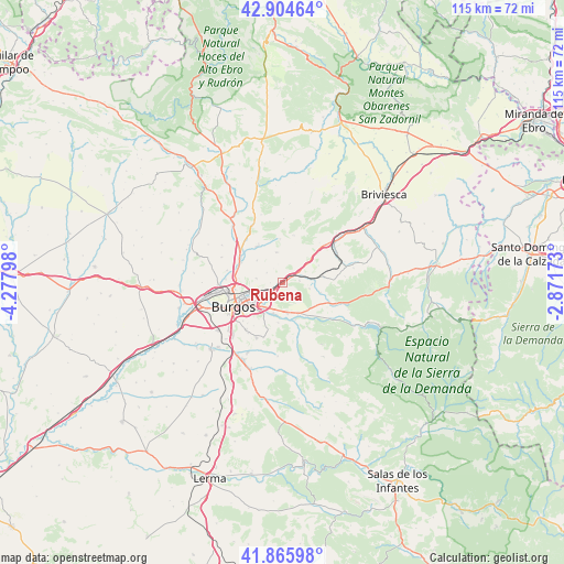
Rubena GPS coordinates[2]
42° 23' 14.856" North, 3° 34' 29.46" West
| Map corner | latitude | longitude |
|---|---|---|
| Upper-left | 42.90464°, | -4.27798° |
| Center: | 42.38746°, | -3.57485° |
| Lower-right: | 41.86598°, | -2.87173° |
| Map W x H: | 115.5×115.5 km | = 71.8×71.8mi |
| max Lat: | 43.74134° ⇑15.6% North |
| Rubena: | 42.38746° |
| min Lat: | ⇓84.4% South 27.64134° |
| min Long | Rubena | max Long |
| -18.00367° | -3.57485° | 4.2899° |
| W 46.7%⇐ | ⇒53.3% E |
Elevation
Elevation of Rubena is 904 m = 2966 ft, and this is 306 m = 1004 ft above average elevation for this country.
| Max E: |
1682 m = 5518 ft | 19.3% |
| Rubena | 904 m 2966 ft | |
| Avg. | 598 m = 1962 ft | |
Min E: |
0 m = 0 ft | 80.7% |
See also: Spain elevation on elevation.city.
Geographical zone
Rubena is located in North temperate zone (between Tropic of Cancer and the Arctic Circle). Distance of this Northern Tropic circle is 2107.1 km =1309.3 mi to South.| Distance of | km | miles | from Rubena |
|---|---|---|---|
| North Pole | 5294 | 3289.5 | to North |
| Arctic Circle | 2688.1 | 1670.3 | to North |
| Tropic Cancer | 2107.1 | 1309.3 | to South |
| Equator | 4713 | 2928.5 | to South |


Nearby cities:
15 places around Rubena: (largest is in red/bold)
• Atapuerca
5.6 km =3.5 mi,  101°
101°
• Barrios de Colina
9.5 km =5.9 mi,  84°
84°
• Burgos
11.6 km =7.2 mi,  243°
243°
• Carcedo de Burgos
11.8 km =7.3 mi,  199°
199°
• Cardeñajimeno
7.4 km =4.6 mi,  210°
210°
• Castrillo del Val
8.2 km =5.1 mi,  185°
185°
• Fresno de Rodilla
8.2 km =5.1 mi,  63°
63°
• Gamonal
8.8 km =5.5 mi,  247°
247°
• Hurones
3.9 km =2.4 mi,  301°
301°
• Ibeas de Juarros
7.1 km =4.4 mi,  152°
152°
• Monasterio de Rodilla
11.6 km =7.2 mi,  47°
47°
• Quintanaortuño
11.3 km =7 mi,  307°
307°
• Quintanapalla
4.2 km =2.6 mi, 54°
• Quintanilla-Vivar
9.9 km =6.2 mi,  288°
288°
• Sotragero
11.6 km =7.2 mi,  282°
282°
Sources, notices
• [Note1] Compared only with cities in Spain existing in our database
• [Src1] Map data: © OpenStreetMap contributors (CC-BY-SA)
• [Src2] Other city data from geonames.org with taken over terms of usage.
• [Src3] Geographical zone / Annual Mean Temperature by Robert A. Rohde @ Wikipedia
