Arévalo geodata
Arévalo (Castille and León) is a seat of a third-order administrative division; located in Spain in Europe/Madrid (GMT+2) time zone. With population of 7,689 people, there are 965 cities with bigger population in this country. Compared to other cities in Spain, 50% of cities are located further ↓South; 68.8% of cities are located further →East and 72% of cities have lower elevation than Arévalo. Note1


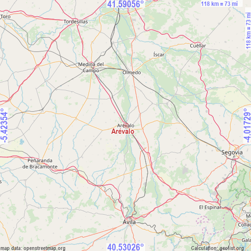
Arévalo GPS coordinates[2]
41° 3' 45.18" North, 4° 43' 13.512" West
| Map corner | latitude | longitude |
|---|---|---|
| Upper-left | 41.59056°, | -5.42354° |
| Center: | 41.06255°, | -4.72042° |
| Lower-right: | 40.53026°, | -4.01729° |
| Map W x H: | 117.9×117.9 km | = 73.3×73.3mi |
| max Lat: | 43.74134° ⇑50% North |
| Arévalo: | 41.06255° |
| min Lat: | ⇓50% South 27.64134° |
| min Long | Arévalo | max Long |
| -18.00367° | -4.72042° | 4.2899° |
| W 31.2%⇐ | ⇒68.8% E |
Elevation
Elevation of Arévalo is 827 m = 2713 ft, and this is 229 m = 751 ft above average elevation for this country.
| Max E: |
1682 m = 5518 ft | 28% |
| Arévalo | 827 m 2713 ft | |
| Avg. | 598 m = 1962 ft | |
Min E: |
0 m = 0 ft | 72% |
See also: Spain elevation on elevation.city.
Geographical zone
Arévalo is located in North temperate zone (between Tropic of Cancer and the Arctic Circle). Distance of this Northern Tropic circle is 1959.8 km =1217.8 mi to South.| Distance of | km | miles | from Arévalo |
|---|---|---|---|
| North Pole | 5441.3 | 3381.1 | to North |
| Arctic Circle | 2835.4 | 1761.8 | to North |
| Tropic Cancer | 1959.8 | 1217.8 | to South |
| Equator | 4565.7 | 2837 | to South |


Nearby cities:
15 places around Arévalo: (largest is in red/bold)
• Aldeaseca
8.2 km =5.1 mi,  259°
259°
• Codorniz
10.1 km =6.3 mi,  86°
86°
• Donhierro
6.3 km =3.9 mi,  18°
18°
• Donvidas
7.8 km =4.8 mi,  292°
292°
• Gutierre-Muñoz
11.2 km =7 mi,  142°
142°
• Martín Muñoz de la Dehesa
2.9 km =1.8 mi,  81°
81°
• Montejo de Arévalo
9.8 km =6.1 mi,  28°
28°
• Nava de Arévalo
10.5 km =6.5 mi,  206°
206°
• Orbita
9.3 km =5.8 mi, 139°
• Palacios de Goda
8.2 km =5.1 mi,  318°
318°
• Rapariegos
6.7 km =4.2 mi,  57°
57°
• San Cristóbal de la Vega
8.4 km =5.2 mi,  49°
49°
• Sinlabajos
9.5 km =5.9 mi,  279°
279°
• Tolocirio
9.9 km =6.2 mi,  36°
36°
• Villanueva del Aceral
11.5 km =7.1 mi, 257°
Sources, notices
• [Note1] Compared only with cities in Spain existing in our database
• [Src1] Map data: © OpenStreetMap contributors (CC-BY-SA)
• [Src2] Other city data from geonames.org with taken over terms of usage.
• [Src3] Geographical zone / Annual Mean Temperature by Robert A. Rohde @ Wikipedia
