Donhierro geodata
Donhierro (Castille and León) is a seat of a third-order administrative division; located in Spain in Europe/Madrid (GMT+2) time zone. With population of 93 people, there are 6020 cities with bigger population in this country. Compared to other cities in Spain, 51.3% of cities are located further ↓South; 68.6% of cities are located further →East and 68.9% of cities have lower elevation than Donhierro. Note1
Administrative division(s):
- Level 1: Castille and León
- Level 2: Provincia de Segovia
- Level 3: Donhierro


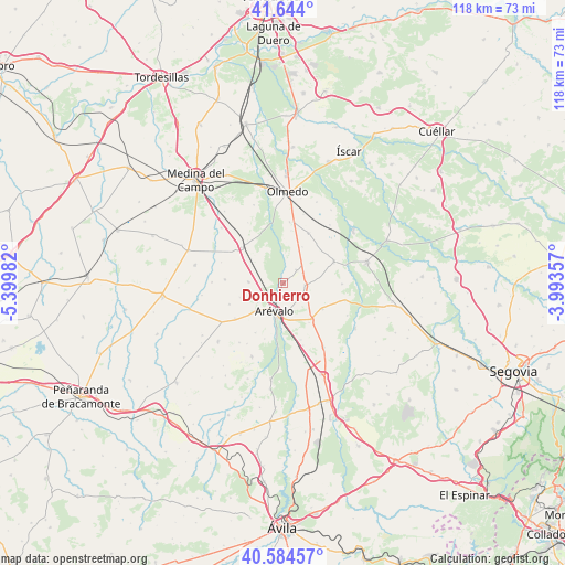
Donhierro GPS coordinates[2]
41° 6' 59.112" North, 4° 41' 48.12" West
| Map corner | latitude | longitude |
|---|---|---|
| Upper-left | 41.644°, | -5.39982° |
| Center: | 41.11642°, | -4.6967° |
| Lower-right: | 40.58457°, | -3.99357° |
| Map W x H: | 117.8×117.8 km | = 73.2×73.2mi |
| max Lat: | 43.74134° ⇑48.7% North |
| Donhierro: | 41.11642° |
| min Lat: | ⇓51.3% South 27.64134° |
| min Long | Donhierro | max Long |
| -18.00367° | -4.6967° | 4.2899° |
| W 31.4%⇐ | ⇒68.6% E |
Elevation
Elevation of Donhierro is 805 m = 2641 ft, and this is 207 m = 679 ft above average elevation for this country.
| Max E: |
1682 m = 5518 ft | 31.1% |
| Donhierro | 805 m 2641 ft | |
| Avg. | 598 m = 1962 ft | |
Min E: |
0 m = 0 ft | 68.9% |
See also: Spain elevation on elevation.city.
Geographical zone
Donhierro is located in North temperate zone (between Tropic of Cancer and the Arctic Circle). Distance of this Northern Tropic circle is 1965.8 km =1221.5 mi to South.| Distance of | km | miles | from Donhierro |
|---|---|---|---|
| North Pole | 5435.3 | 3377.3 | to North |
| Arctic Circle | 2829.5 | 1758.2 | to North |
| Tropic Cancer | 1965.8 | 1221.5 | to South |
| Equator | 4571.7 | 2840.7 | to South |


Nearby cities:
15 places around Donhierro: (largest is in red/bold)
• Almenara de Adaja
11 km =6.8 mi,  8°
8°
• Arévalo
6.3 km =3.9 mi,  198°
198°
• Ataquines
11.6 km =7.2 mi,  309°
309°
• Codorniz
9.7 km =6 mi,  123°
123°
• Donvidas
9.7 km =6 mi,  251°
251°
• Fuente de Santa Cruz
11.6 km =7.2 mi,  26°
26°
• Martín Muñoz de la Dehesa
5.6 km =3.5 mi,  171°
171°
• Montejo de Arévalo
3.8 km =2.4 mi,  45°
45°
• Palacios de Goda
7.4 km =4.6 mi,  271°
271°
• Puras
8.4 km =5.2 mi, 27°
• Rapariegos
4.4 km =2.7 mi, 122°
• San Cristóbal de la Vega
4.4 km =2.7 mi,  96°
96°
• San Pablo de la Moraleja
8.4 km =5.2 mi, 306°
• Santiuste de San Juan Bautista
11.3 km =7 mi,  67°
67°
• Tolocirio
4.3 km =2.7 mi,  62°
62°
Sources, notices
• [Note1] Compared only with cities in Spain existing in our database
• [Src1] Map data: © OpenStreetMap contributors (CC-BY-SA)
• [Src2] Other city data from geonames.org with taken over terms of usage.
• [Src3] Geographical zone / Annual Mean Temperature by Robert A. Rohde @ Wikipedia
