Guitiriz geodata
Guitiriz (Galicia) is a seat of a third-order administrative division; located in Spain in Europe/Madrid (GMT+2) time zone. With population of 6,033 people, there are 1134 cities with bigger population in this country. Compared to other cities in Spain, 96.2% of cities are located further ↓South; 96.1% of cities are located further →East and 65.5% of cities have higher elevation than Guitiriz. Note1


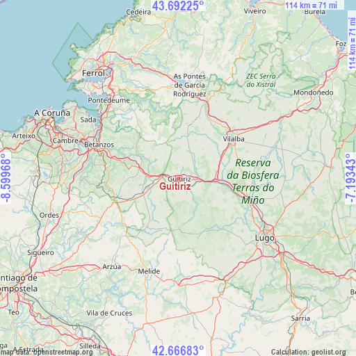
Guitiriz GPS coordinates[2]
43° 10' 54.084" North, 7° 53' 47.616" West
| Map corner | latitude | longitude |
|---|---|---|
| Upper-left | 43.69225°, | -8.59968° |
| Center: | 43.18169°, | -7.89656° |
| Lower-right: | 42.66683°, | -7.19343° |
| Map W x H: | 114×114 km | = 70.8×70.8mi |
| max Lat: | 43.74134° ⇑3.8% North |
| Guitiriz: | 43.18169° |
| min Lat: | ⇓96.2% South 27.64134° |
| min Long | Guitiriz | max Long |
| -18.00367° | -7.89656° | 4.2899° |
| W 3.9%⇐ | ⇒96.1% E |
Elevation
Elevation of Guitiriz is 454 m = 1490 ft, and this is 144 m = 472 ft below average elevation for this country.
| Max E: |
1682 m = 5518 ft | 65.5% |
| Avg. | 598 m = 1962 ft | |
| Guitiriz | 454 m = 1490 ft | |
Min E: |
0 m = 0 ft | 34.5% |
See also: Spain elevation on elevation.city.
Geographical zone
Guitiriz is located in North temperate zone (between Tropic of Cancer and the Arctic Circle). Distance of this Northern Tropic circle is 2195.4 km =1364.2 mi to South.| Distance of | km | miles | from Guitiriz |
|---|---|---|---|
| North Pole | 5205.7 | 3234.7 | to North |
| Arctic Circle | 2599.8 | 1615.4 | to North |
| Tropic Cancer | 2195.4 | 1364.2 | to South |
| Equator | 4801.4 | 2983.5 | to South |


Nearby cities:
15 places around Guitiriz: (largest is in red/bold)
• Aranga
11.4 km =7.1 mi,  301°
301°
• Begonte
17.4 km =10.8 mi,  101°
101°
• Boimorto
27.9 km =17.3 mi,  223°
223°
• Cesuras
24.7 km =15.3 mi,  267°
267°
• Coirós
23.2 km =14.4 mi,  289°
289°
• Curtis
21.4 km =13.3 mi,  252°
252°
• Friol
18.6 km =11.6 mi,  153°
153°
• Irixoa
17.5 km =10.9 mi,  311°
311°
• Monfero
19.5 km =12.1 mi,  330°
330°
• Outeiro de Rei
24.5 km =15.2 mi,  111°
111°
• Paderne
25.3 km =15.7 mi, 297°
• Rábade
23.8 km =14.8 mi, 107°
• Sobrado
19.1 km =11.9 mi,  213°
213°
• Vilalba
21.7 km =13.5 mi,  53°
53°
• Vilasantar
22 km =13.7 mi,  236°
236°
Sources, notices
• [Note1] Compared only with cities in Spain existing in our database
• [Src1] Map data: © OpenStreetMap contributors (CC-BY-SA)
• [Src2] Other city data from geonames.org with taken over terms of usage.
• [Src3] Geographical zone / Annual Mean Temperature by Robert A. Rohde @ Wikipedia
