Almazán geodata
Almazán (Castille and León) is a seat of a third-order administrative division; located in Spain in Europe/Madrid (GMT+2) time zone. With population of 5,773 people, there are 1166 cities with bigger population in this country. Compared to other cities in Spain, 60.6% of cities are located further ↓South; 60.6% of cities are located further ←West and 84.7% of cities have lower elevation than Almazán. Note1


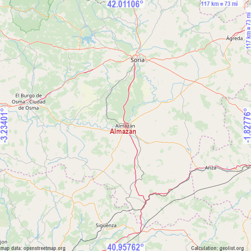
Almazán GPS coordinates[2]
41° 29' 11.328" North, 2° 31' 51.168" West
| Map corner | latitude | longitude |
|---|---|---|
| Upper-left | 42.01106°, | -3.23401° |
| Center: | 41.48648°, | -2.53088° |
| Lower-right: | 40.95762°, | -1.82776° |
| Map W x H: | 117.1×117.1 km | = 72.8×72.8mi |
| max Lat: | 43.74134° ⇑39.4% North |
| Almazán: | 41.48648° |
| min Lat: | ⇓60.6% South 27.64134° |
| min Long | Almazán | max Long |
| -18.00367° | -2.53088° | 4.2899° |
| W 60.6%⇐ | ⇒39.4% E |
Elevation
Elevation of Almazán is 948 m = 3110 ft, and this is 350 m = 1148 ft above average elevation for this country.
| Max E: |
1682 m = 5518 ft | 15.3% |
| Almazán | 948 m 3110 ft | |
| Avg. | 598 m = 1962 ft | |
Min E: |
0 m = 0 ft | 84.7% |
See also: Spain elevation on elevation.city.
Geographical zone
Almazán is located in North temperate zone (between Tropic of Cancer and the Arctic Circle). Distance of this Northern Tropic circle is 2006.9 km =1247 mi to South.| Distance of | km | miles | from Almazán |
|---|---|---|---|
| North Pole | 5394.2 | 3351.8 | to North |
| Arctic Circle | 2788.3 | 1732.6 | to North |
| Tropic Cancer | 2006.9 | 1247 | to South |
| Equator | 4612.9 | 2866.3 | to South |


Nearby cities:
15 places around Almazán: (largest is in red/bold)
• Adradas
15.8 km =9.8 mi,  162°
162°
• Barca
8.4 km =5.2 mi,  245°
245°
• Borjabad
15.5 km =9.6 mi,  61°
61°
• Coscurita
7.4 km =4.6 mi,  141°
141°
• Cubo de la Solana
15.8 km =9.8 mi,  35°
35°
• Escobosa de Almazán
13.3 km =8.3 mi,  90°
90°
• Frechilla de Almazán
6.8 km =4.2 mi,  168°
168°
• Matamala de Almazán
9.4 km =5.8 mi,  283°
283°
• Morón de Almazán
12.7 km =7.9 mi,  129°
129°
• Nepas
11.9 km =7.4 mi,  68°
68°
• Nolay
15.7 km =9.8 mi, 73°
• Soliedra
12.6 km =7.8 mi,  98°
98°
• Tardelcuende
15.2 km =9.4 mi,  321°
321°
• Velamazán
14.6 km =9.1 mi, 253°
• Viana de Duero
7.9 km =4.9 mi,  47°
47°
Sources, notices
• [Note1] Compared only with cities in Spain existing in our database
• [Src1] Map data: © OpenStreetMap contributors (CC-BY-SA)
• [Src2] Other city data from geonames.org with taken over terms of usage.
• [Src3] Geographical zone / Annual Mean Temperature by Robert A. Rohde @ Wikipedia
