Tardelcuende geodata
Tardelcuende (Castille and León) is a seat of a third-order administrative division; located in Spain in Europe/Madrid (GMT+2) time zone. With population of 598 people, there are 3616 cities with bigger population in this country. Compared to other cities in Spain, 63.3% of cities are located further ↓South; 59.3% of cities are located further ←West and 87.6% of cities have lower elevation than Tardelcuende. Note1
Administrative division(s):
- Level 1: Castille and León
- Level 2: Provincia de Soria
- Level 3: Tardelcuende


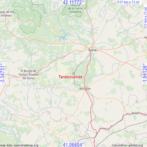
Tardelcuende GPS coordinates[2]
41° 35' 38.472" North, 2° 38' 39.804" West
| Map corner | latitude | longitude |
|---|---|---|
| Upper-left | 42.11772°, | -3.34751° |
| Center: | 41.59402°, | -2.64439° |
| Lower-right: | 41.06604°, | -1.94126° |
| Map W x H: | 116.9×116.9 km | = 72.6×72.6mi |
| max Lat: | 43.74134° ⇑36.7% North |
| Tardelcuende: | 41.59402° |
| min Lat: | ⇓63.3% South 27.64134° |
| min Long | Tardelcuende | max Long |
| -18.00367° | -2.64439° | 4.2899° |
| W 59.3%⇐ | ⇒40.7% E |
Elevation
Elevation of Tardelcuende is 990 m = 3248 ft, and this is 392 m = 1286 ft above average elevation for this country.
| Max E: |
1682 m = 5518 ft | 12.4% |
| Tardelcuende | 990 m 3248 ft | |
| Avg. | 598 m = 1962 ft | |
Min E: |
0 m = 0 ft | 87.6% |
See also: Spain elevation on elevation.city.
Geographical zone
Tardelcuende is located in North temperate zone (between Tropic of Cancer and the Arctic Circle). Distance of this Northern Tropic circle is 2018.9 km =1254.5 mi to South.| Distance of | km | miles | from Tardelcuende |
|---|---|---|---|
| North Pole | 5382.2 | 3344.3 | to North |
| Arctic Circle | 2776.4 | 1725.2 | to North |
| Tropic Cancer | 2018.9 | 1254.5 | to South |
| Equator | 4624.8 | 2873.7 | to South |


Nearby cities:
15 places around Tardelcuende: (largest is in red/bold)
• Almazán
15.2 km =9.4 mi,  141°
141°
• Barca
15.6 km =9.7 mi,  173°
173°
• Bayubas de Arriba
20.6 km =12.8 mi,  258°
258°
• Blacos
20.2 km =12.6 mi,  298°
298°
• Calatañazor
18.6 km =11.6 mi,  308°
308°
• Centenera de Andaluz
11.5 km =7.1 mi,  212°
212°
• Cubo de la Solana
18.5 km =11.5 mi,  87°
87°
• Fuentepinilla
10.3 km =6.4 mi,  252°
252°
• Matamala de Almazán
9.8 km =6.1 mi,  178°
178°
• Quintana Redonda
5.6 km =3.5 mi,  26°
26°
• Tajueco
18.1 km =11.2 mi, 249°
• Valderrodilla
14 km =8.7 mi, 255°
• Velamazán
16.8 km =10.4 mi,  195°
195°
• Viana de Duero
16.7 km =10.4 mi,  113°
113°
• Villaciervos
18.8 km =11.7 mi,  4°
4°
Sources, notices
• [Note1] Compared only with cities in Spain existing in our database
• [Src1] Map data: © OpenStreetMap contributors (CC-BY-SA)
• [Src2] Other city data from geonames.org with taken over terms of usage.
• [Src3] Geographical zone / Annual Mean Temperature by Robert A. Rohde @ Wikipedia
