Nolay geodata
Nolay (Castille and León) is a seat of a third-order administrative division; located in Spain in Europe/Madrid (GMT+2) time zone. With population of 88 people, there are 6061 cities with bigger population in this country. Compared to other cities in Spain, 61.4% of cities are located further ↓South; 62.9% of cities are located further ←West and 92.3% of cities have lower elevation than Nolay. Note1


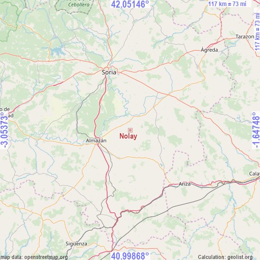
Nolay GPS coordinates[2]
41° 31' 37.956" North, 2° 21' 2.196" West
| Map corner | latitude | longitude |
|---|---|---|
| Upper-left | 42.05146°, | -3.05373° |
| Center: | 41.52721°, | -2.35061° |
| Lower-right: | 40.99868°, | -1.64748° |
| Map W x H: | 117.1×117.1 km | = 72.8×72.8mi |
| max Lat: | 43.74134° ⇑38.6% North |
| Nolay: | 41.52721° |
| min Lat: | ⇓61.4% South 27.64134° |
| min Long | Nolay | max Long |
| -18.00367° | -2.35061° | 4.2899° |
| W 62.9%⇐ | ⇒37.1% E |
Elevation
Elevation of Nolay is 1077 m = 3533 ft, and this is 479 m = 1572 ft above average elevation for this country.
| Max E: |
1682 m = 5518 ft | 7.7% |
| Nolay | 1077 m 3533 ft | |
| Avg. | 598 m = 1962 ft | |
Min E: |
0 m = 0 ft | 92.3% |
See also: Spain elevation on elevation.city.
Geographical zone
Nolay is located in North temperate zone (between Tropic of Cancer and the Arctic Circle). Distance of this Northern Tropic circle is 2011.5 km =1249.9 mi to South.| Distance of | km | miles | from Nolay |
|---|---|---|---|
| North Pole | 5389.7 | 3349 | to North |
| Arctic Circle | 2783.8 | 1729.8 | to North |
| Tropic Cancer | 2011.5 | 1249.9 | to South |
| Equator | 4617.4 | 2869.1 | to South |


Nearby cities:
15 places around Nolay: (largest is in red/bold)
• Alentisque
12 km =7.5 mi,  172°
172°
• Bliecos
6.6 km =4.1 mi,  89°
89°
• Borjabad
3.1 km =1.9 mi,  335°
335°
• Cañamaque
13.1 km =8.1 mi,  134°
134°
• Coscurita
14.6 km =9.1 mi,  225°
225°
• Cubo de la Solana
10.2 km =6.3 mi,  324°
324°
• Escobosa de Almazán
4.9 km =3 mi,  200°
200°
• Maján
7.6 km =4.7 mi,  148°
148°
• Momblona
9.2 km =5.7 mi,  177°
177°
• Morón de Almazán
13.7 km =8.5 mi, 202°
• Nepas
4 km =2.5 mi,  268°
268°
• Soliedra
6.9 km =4.3 mi, 201°
• Tejado
9.8 km =6.1 mi,  45°
45°
• Velilla de los Ajos
8.9 km =5.5 mi,  117°
117°
• Viana de Duero
9.2 km =5.7 mi, 274°
Sources, notices
• [Note1] Compared only with cities in Spain existing in our database
• [Src1] Map data: © OpenStreetMap contributors (CC-BY-SA)
• [Src2] Other city data from geonames.org with taken over terms of usage.
• [Src3] Geographical zone / Annual Mean Temperature by Robert A. Rohde @ Wikipedia
