Borjabad geodata
Borjabad (Castille and León) is a seat of a third-order administrative division; located in Spain in Europe/Madrid (GMT+2) time zone. With population of 56 people, there are 6395 cities with bigger population in this country. Compared to other cities in Spain, 62.2% of cities are located further ↓South; 62.7% of cities are located further ←West and 88.8% of cities have lower elevation than Borjabad. Note1
Administrative division(s):
- Level 1: Castille and León
- Level 2: Provincia de Soria
- Level 3: Borjabad


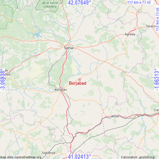
Borjabad GPS coordinates[2]
41° 33' 8.82" North, 2° 21' 58.5" West
| Map corner | latitude | longitude |
|---|---|---|
| Upper-left | 42.07649°, | -3.06938° |
| Center: | 41.55245°, | -2.36625° |
| Lower-right: | 41.02413°, | -1.66313° |
| Map W x H: | 117×117 km | = 72.7×72.7mi |
| max Lat: | 43.74134° ⇑37.8% North |
| Borjabad: | 41.55245° |
| min Lat: | ⇓62.2% South 27.64134° |
| min Long | Borjabad | max Long |
| -18.00367° | -2.36625° | 4.2899° |
| W 62.7%⇐ | ⇒37.3% E |
Elevation
Elevation of Borjabad is 1011 m = 3317 ft, and this is 413 m = 1355 ft above average elevation for this country.
| Max E: |
1682 m = 5518 ft | 11.2% |
| Borjabad | 1011 m 3317 ft | |
| Avg. | 598 m = 1962 ft | |
Min E: |
0 m = 0 ft | 88.8% |
See also: Spain elevation on elevation.city.
Geographical zone
Borjabad is located in North temperate zone (between Tropic of Cancer and the Arctic Circle). Distance of this Northern Tropic circle is 2014.3 km =1251.6 mi to South.| Distance of | km | miles | from Borjabad |
|---|---|---|---|
| North Pole | 5386.9 | 3347.3 | to North |
| Arctic Circle | 2781 | 1728 | to North |
| Tropic Cancer | 2014.3 | 1251.6 | to South |
| Equator | 4620.2 | 2870.9 | to South |


Nearby cities:
15 places around Borjabad: (largest is in red/bold)
• Aldealafuente
13.7 km =8.5 mi,  14°
14°
• Alentisque
14.9 km =9.3 mi,  168°
168°
• Aliud
14.7 km =9.1 mi,  39°
39°
• Bliecos
8.4 km =5.2 mi,  109°
109°
• Cubo de la Solana
7.2 km =4.5 mi,  320°
320°
• Escobosa de Almazán
7.4 km =4.6 mi,  183°
183°
• Gómara
14.2 km =8.8 mi,  56°
56°
• Maján
10.7 km =6.6 mi,  150°
150°
• Momblona
12.1 km =7.5 mi, 172°
• Nepas
4 km =2.5 mi,  222°
222°
• Nolay
3.1 km =1.9 mi,  155°
155°
• Soliedra
9.3 km =5.8 mi,  187°
187°
• Tejado
9.2 km =5.7 mi, 63°
• Velilla de los Ajos
11.5 km =7.1 mi,  126°
126°
• Viana de Duero
8.1 km =5 mi,  255°
255°
Sources, notices
• [Note1] Compared only with cities in Spain existing in our database
• [Src1] Map data: © OpenStreetMap contributors (CC-BY-SA)
• [Src2] Other city data from geonames.org with taken over terms of usage.
• [Src3] Geographical zone / Annual Mean Temperature by Robert A. Rohde @ Wikipedia
