Ajamil geodata
Ajamil (La Rioja) is a seat of a third-order administrative division; located in Spain in Europe/Madrid (GMT+2) time zone. With population of 83 people, there are 6106 cities with bigger population in this country. Compared to other cities in Spain, 78.3% of cities are located further ↓South; 61.1% of cities are located further ←West and 90.8% of cities have lower elevation than Ajamil. Note1
Administrative division(s):
- Level 1: La Rioja
- Level 2: Provincia de La Rioja
- Level 3: Ajamil de Cameros


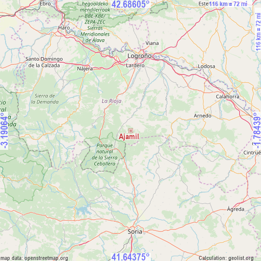
Ajamil GPS coordinates[2]
42° 10' 1.38" North, 2° 29' 15.072" West
| Map corner | latitude | longitude |
|---|---|---|
| Upper-left | 42.68605°, | -3.19064° |
| Center: | 42.16705°, | -2.48752° |
| Lower-right: | 41.64375°, | -1.78439° |
| Map W x H: | 115.9×115.9 km | = 72×72mi |
| max Lat: | 43.74134° ⇑21.7% North |
| Ajamil: | 42.16705° |
| min Lat: | ⇓78.3% South 27.64134° |
| min Long | Ajamil | max Long |
| -18.00367° | -2.48752° | 4.2899° |
| W 61.1%⇐ | ⇒38.9% E |
Elevation
Elevation of Ajamil is 1046 m = 3432 ft, and this is 448 m = 1470 ft above average elevation for this country.
| Max E: |
1682 m = 5518 ft | 9.2% |
| Ajamil | 1046 m 3432 ft | |
| Avg. | 598 m = 1962 ft | |
Min E: |
0 m = 0 ft | 90.8% |
See also: Spain elevation on elevation.city.
Geographical zone
Ajamil is located in North temperate zone (between Tropic of Cancer and the Arctic Circle). Distance of this Northern Tropic circle is 2082.6 km =1294.1 mi to South.| Distance of | km | miles | from Ajamil |
|---|---|---|---|
| North Pole | 5318.5 | 3304.8 | to North |
| Arctic Circle | 2712.6 | 1685.5 | to North |
| Tropic Cancer | 2082.6 | 1294.1 | to South |
| Equator | 4688.5 | 2913.3 | to South |


Nearby cities:
15 places around Ajamil: (largest is in red/bold)
• Almarza de Cameros
10.7 km =6.6 mi,  300°
300°
• Cabezón de Cameros
4.3 km =2.7 mi,  321°
321°
• Gallinero de Cameros
10.8 km =6.7 mi,  273°
273°
• Hornillos de Cameros
7.4 km =4.6 mi,  49°
49°
• Jalón de Cameros
5.7 km =3.5 mi,  357°
357°
• Laguna de Cameros
4.6 km =2.9 mi,  280°
280°
• Muro en Cameros
7.4 km =4.6 mi,  331°
331°
• Pinillos
9.7 km =6 mi,  291°
291°
• Pradillo
12.8 km =8 mi, 274°
• Rabanera
2.5 km =1.6 mi,  1°
1°
• San Román de Cameros
7.4 km =4.6 mi,  8°
8°
• Santa Cruz de Yanguas
12.1 km =7.5 mi,  164°
164°
• Terroba
10.7 km =6.6 mi,  19°
19°
• Torre en Cameros
8.6 km =5.3 mi,  343°
343°
• Zarzosa
12 km =7.5 mi,  81°
81°
In other languages:
- In Spanish: Ajamil de Cameros
- In France: Ajamil de Cameros
- In Russian: Ахамиль
- In Chinese: 阿哈米尔德卡梅罗斯
Sources, notices
• [Note1] Compared only with cities in Spain existing in our database
• [Src1] Map data: © OpenStreetMap contributors (CC-BY-SA)
• [Src2] Other city data from geonames.org with taken over terms of usage.
• [Src3] Geographical zone / Annual Mean Temperature by Robert A. Rohde @ Wikipedia
