Hornillos de Cameros geodata
Hornillos de Cameros (La Rioja) is a seat of a third-order administrative division; located in Spain in Europe/Madrid (GMT+2) time zone. With population of 15 people, there are 6744 cities with bigger population in this country. Compared to other cities in Spain, 79.5% of cities are located further ↓South; 62% of cities are located further ←West and 95.2% of cities have lower elevation than Hornillos de Cameros. Note1
Administrative division(s):
- Level 1: La Rioja
- Level 2: Provincia de La Rioja
- Level 3: Hornillos de Cameros


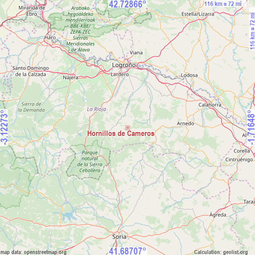
Hornillos de Cameros GPS coordinates[2]
42° 12' 36.036" North, 2° 25' 10.56" West
| Map corner | latitude | longitude |
|---|---|---|
| Upper-left | 42.72866°, | -3.12273° |
| Center: | 42.21001°, | -2.4196° |
| Lower-right: | 41.68707°, | -1.71648° |
| Map W x H: | 115.8×115.8 km | = 72×72mi |
| max Lat: | 43.74134° ⇑20.5% North |
| Hornillos de Cameros: | 42.21001° |
| min Lat: | ⇓79.5% South 27.64134° |
| min Long | Hornillos de Ca | max Long |
| -18.00367° | -2.4196° | 4.2899° |
| W 62%⇐ | ⇒38% E |
Elevation
Elevation of Hornillos de Cameros is 1142 m = 3747 ft, and this is 544 m = 1785 ft above average elevation for this country.
| Max E: |
1682 m = 5518 ft | 4.8% |
| Hornillos de Cameros | 1142 m 3747 ft | |
| Avg. | 598 m = 1962 ft | |
Min E: |
0 m = 0 ft | 95.2% |
See also: Spain elevation on elevation.city.
Geographical zone
Hornillos de Cameros is located in North temperate zone (between Tropic of Cancer and the Arctic Circle). Distance of this Northern Tropic circle is 2087.4 km =1297 mi to South.| Distance of | km | miles | from Hornillos de Cameros |
|---|---|---|---|
| North Pole | 5313.7 | 3301.8 | to North |
| Arctic Circle | 2707.9 | 1682.6 | to North |
| Tropic Cancer | 2087.4 | 1297 | to South |
| Equator | 4693.3 | 2916.3 | to South |


Nearby cities:
15 places around Hornillos de Cameros: (largest is in red/bold)
• Ajamil
7.4 km =4.6 mi,  229°
229°
• Cabezón de Cameros
8.4 km =5.2 mi,  260°
260°
• Jalón de Cameros
5.9 km =3.7 mi,  278°
278°
• Laguna de Cameros
10.9 km =6.8 mi,  248°
248°
• Leza de Río Leza
13.3 km =8.3 mi,  4°
4°
• Munilla
10.5 km =6.5 mi,  102°
102°
• Muro en Cameros
9.3 km =5.8 mi, 280°
• Rabanera
6 km =3.7 mi, 247°
• Robres del Castillo
12.8 km =8 mi,  54°
54°
• San Román de Cameros
5.2 km =3.2 mi,  299°
299°
• Soto en Cameros
8.5 km =5.3 mi,  356°
356°
• Terroba
5.7 km =3.5 mi,  339°
339°
• Torre en Cameros
8.8 km =5.5 mi,  293°
293°
• Yanguas
13.7 km =8.5 mi,  151°
151°
• Zarzosa
7 km =4.3 mi,  115°
115°
Sources, notices
• [Note1] Compared only with cities in Spain existing in our database
• [Src1] Map data: © OpenStreetMap contributors (CC-BY-SA)
• [Src2] Other city data from geonames.org with taken over terms of usage.
• [Src3] Geographical zone / Annual Mean Temperature by Robert A. Rohde @ Wikipedia
