Terroba geodata
Terroba (La Rioja) is a seat of a third-order administrative division; located in Spain in Europe/Madrid (GMT+2) time zone. With population of 29 people, there are 6669 cities with bigger population in this country. Compared to other cities in Spain, 80.8% of cities are located further ↓South; 61.6% of cities are located further ←West and 66.5% of cities have lower elevation than Terroba. Note1


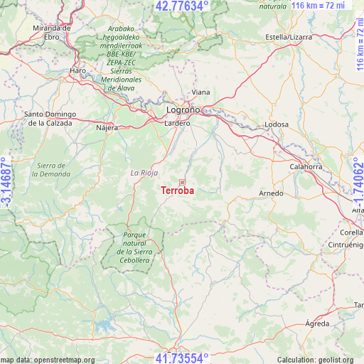
Terroba GPS coordinates[2]
42° 15' 29.124" North, 2° 26' 37.5" West
| Map corner | latitude | longitude |
|---|---|---|
| Upper-left | 42.77634°, | -3.14687° |
| Center: | 42.25809°, | -2.44375° |
| Lower-right: | 41.73554°, | -1.74062° |
| Map W x H: | 115.7×115.7 km | = 71.9×71.9mi |
| max Lat: | 43.74134° ⇑19.2% North |
| Terroba: | 42.25809° |
| min Lat: | ⇓80.8% South 27.64134° |
| min Long | Terroba | max Long |
| -18.00367° | -2.44375° | 4.2899° |
| W 61.6%⇐ | ⇒38.4% E |
Elevation
Elevation of Terroba is 788 m = 2585 ft, and this is 190 m = 623 ft above average elevation for this country.
| Max E: |
1682 m = 5518 ft | 33.5% |
| Terroba | 788 m 2585 ft | |
| Avg. | 598 m = 1962 ft | |
Min E: |
0 m = 0 ft | 66.5% |
See also: Spain elevation on elevation.city.
Geographical zone
Terroba is located in North temperate zone (between Tropic of Cancer and the Arctic Circle). Distance of this Northern Tropic circle is 2092.7 km =1300.3 mi to South.| Distance of | km | miles | from Terroba |
|---|---|---|---|
| North Pole | 5308.4 | 3298.5 | to North |
| Arctic Circle | 2702.5 | 1679.3 | to North |
| Tropic Cancer | 2092.7 | 1300.3 | to South |
| Equator | 4698.7 | 2919.6 | to South |


Nearby cities:
15 places around Terroba: (largest is in red/bold)
• Ajamil
10.7 km =6.6 mi,  199°
199°
• Albelda de Iregua
11.4 km =7.1 mi,  347°
347°
• Cabezón de Cameros
9.2 km =5.7 mi,  222°
222°
• Clavijo
10.2 km =6.3 mi,  7°
7°
• Hornillos de Cameros
5.7 km =3.5 mi,  159°
159°
• Jalón de Cameros
5.9 km =3.7 mi, 220°
• Leza de Río Leza
8.5 km =5.3 mi,  21°
21°
• Muro en Cameros
8 km =5 mi,  242°
242°
• Nalda
9.2 km =5.7 mi,  337°
337°
• Rabanera
8.4 km =5.2 mi, 204°
• Ribafrecha
11.7 km =7.3 mi, 22°
• San Román de Cameros
3.8 km =2.4 mi, 221°
• Soto en Cameros
3.4 km =2.1 mi,  25°
25°
• Torre en Cameros
6.4 km =4 mi,  253°
253°
• Viguera
9.3 km =5.8 mi,  307°
307°
Sources, notices
• [Note1] Compared only with cities in Spain existing in our database
• [Src1] Map data: © OpenStreetMap contributors (CC-BY-SA)
• [Src2] Other city data from geonames.org with taken over terms of usage.
• [Src3] Geographical zone / Annual Mean Temperature by Robert A. Rohde @ Wikipedia
