Fuencarral-El Pardo geodata
Fuencarral-El Pardo (Madrid) is a section of populated place; located in Spain in Europe/Madrid (GMT+2) time zone. With population of 220,085 people, there are 28 cities with bigger population in this country. Compared to other cities in Spain, 61.9% of cities are located further ↑North; 55.8% of cities are located further →East and 52.7% of cities have lower elevation than Fuencarral-El Pardo. Note1
Administrative division(s):
- Level 1: Madrid
- Level 2: Provincia de Madrid
- Level 3: Madrid
- Level 4: Fuencarral - El Pardo


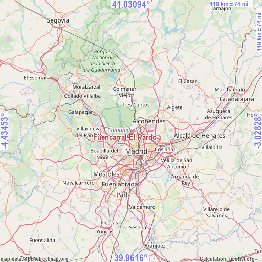
Fuencarral-El Pardo GPS coordinates[2]
40° 29' 54.24" North, 3° 43' 53.04" West
| Map corner | latitude | longitude |
|---|---|---|
| Upper-left | 41.03094°, | -4.43453° |
| Center: | 40.4984°, | -3.7314° |
| Lower-right: | 39.9616°, | -3.02828° |
| Map W x H: | 118.9×118.9 km | = 73.9×73.9mi |
| max Lat: | 43.74134° ⇑61.9% North |
| Fuencarral-El Pardo: | 40.4984° |
| min Lat: | ⇓38.1% South 27.64134° |
| min Long | Fuencarral-El P | max Long |
| -18.00367° | -3.7314° | 4.2899° |
| W 44.2%⇐ | ⇒55.8% E |
Elevation
Elevation of Fuencarral-El Pardo is 687 m = 2254 ft, and this is 89 m = 292 ft above average elevation for this country.
| Max E: |
1682 m = 5518 ft | 47.3% |
| Fuencarral-El Pardo | 687 m 2254 ft | |
| Avg. | 598 m = 1962 ft | |
Min E: |
0 m = 0 ft | 52.7% |
See also: Fuencarral-El Pardo elevation on elevation.city.
Geographical zone
Fuencarral-El Pardo is located in North temperate zone (between Tropic of Cancer and the Arctic Circle). Distance of this Northern Tropic circle is 1897.1 km =1178.8 mi to South.| Distance of | km | miles | from Fuencarral-El Pardo |
|---|---|---|---|
| North Pole | 5504.1 | 3420.1 | to North |
| Arctic Circle | 2898.2 | 1800.9 | to North |
| Tropic Cancer | 1897.1 | 1178.8 | to South |
| Equator | 4503 | 2798 | to South |


Nearby cities:
15 places around Fuencarral-El Pardo: (largest is in red/bold)
• Alcobendas
9.3 km =5.8 mi,  54°
54°
• Chamartín
6.1 km =3.8 mi,  131°
131°
• Chamberí
7.5 km =4.7 mi,  161°
161°
• City Center
9.2 km =5.7 mi, 164°
• Ciudad Lineal
9 km =5.6 mi, 131°
• El Pardo
3.9 km =2.4 mi,  297°
297°
• Hortaleza
8.1 km =5 mi,  109°
109°
• Las Tablas
5.1 km =3.2 mi,  79°
79°
• Madrid
9.4 km =5.8 mi,  165°
165°
• Moncloa-Aravaca
7 km =4.3 mi,  180°
180°
• Pinar de Chamartín
5.7 km =3.5 mi, 111°
• Pozuelo de Alarcón
10.1 km =6.3 mi,  223°
223°
• Retiro
10.3 km =6.4 mi, 156°
• Salamanca
8.8 km =5.5 mi,  150°
150°
• Tetuán de las Victorias
5.2 km =3.2 mi, 146°
Sources, notices
• [Note1] Compared only with cities in Spain existing in our database
• [Src1] Map data: © OpenStreetMap contributors (CC-BY-SA)
• [Src2] Other city data from geonames.org with taken over terms of usage.
• [Src3] Geographical zone / Annual Mean Temperature by Robert A. Rohde @ Wikipedia
