Retiro geodata
Retiro (Madrid) is a section of populated place; located in Spain in Europe/Madrid (GMT+2) time zone. With population of 126,058 people, there are 72 cities with bigger population in this country. Compared to other cities in Spain, 63.8% of cities are located further ↑North; 55.1% of cities are located further →East and 50.6% of cities have lower elevation than Retiro. Note1
Administrative division(s):
- Level 1: Madrid
- Level 2: Provincia de Madrid
- Level 3: Madrid
- Level 4: Retiro


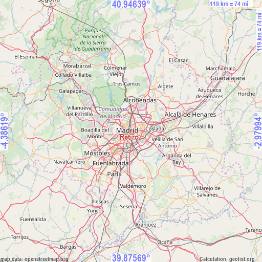
Retiro GPS coordinates[2]
40° 24' 47.412" North, 3° 40' 59.052" West
| Map corner | latitude | longitude |
|---|---|---|
| Upper-left | 40.94639°, | -4.38619° |
| Center: | 40.41317°, | -3.68307° |
| Lower-right: | 39.87569°, | -2.97994° |
| Map W x H: | 119.1×119 km | = 74×73.9mi |
| max Lat: | 43.74134° ⇑63.8% North |
| Retiro: | 40.41317° |
| min Lat: | ⇓36.2% South 27.64134° |
| min Long | Retiro | max Long |
| -18.00367° | -3.68307° | 4.2899° |
| W 44.9%⇐ | ⇒55.1% E |
Elevation
Elevation of Retiro is 665 m = 2182 ft, and this is 67 m = 220 ft above average elevation for this country.
| Max E: |
1682 m = 5518 ft | 49.4% |
| Retiro | 665 m 2182 ft | |
| Avg. | 598 m = 1962 ft | |
Min E: |
0 m = 0 ft | 50.6% |
See also: Retiro elevation on elevation.city.
Geographical zone
Retiro is located in North temperate zone (between Tropic of Cancer and the Arctic Circle). Distance of this Northern Tropic circle is 1887.6 km =1172.9 mi to South.| Distance of | km | miles | from Retiro |
|---|---|---|---|
| North Pole | 5513.5 | 3425.9 | to North |
| Arctic Circle | 2907.7 | 1806.8 | to North |
| Tropic Cancer | 1887.6 | 1172.9 | to South |
| Equator | 4493.5 | 2792.1 | to South |


Nearby cities:
15 places around Retiro: (largest is in red/bold)
• Arganzuela
1.8 km =1.1 mi,  217°
217°
• Carabanchel
4.3 km =2.7 mi,  234°
234°
• Chamartín
5.5 km =3.4 mi,  5°
5°
• Chamberí
2.9 km =1.8 mi,  322°
322°
• City Center
1.8 km =1.1 mi,  288°
288°
• Ciudad Lineal
4.4 km =2.7 mi,  37°
37°
• Latina
5.9 km =3.7 mi,  243°
243°
• Madrid
1.7 km =1.1 mi,  282°
282°
• Moncloa-Aravaca
4.8 km =3 mi,  301°
301°
• Moratalaz
2.9 km =1.8 mi,  102°
102°
• Puente de Vallecas
2.8 km =1.7 mi,  140°
140°
• Salamanca
1.9 km =1.2 mi, 8°
• San Blas-Canillejas
6.4 km =4 mi,  63°
63°
• Tetuán de las Victorias
5.3 km =3.3 mi,  346°
346°
• Usera
3.1 km =1.9 mi,  208°
208°
Sources, notices
• [Note1] Compared only with cities in Spain existing in our database
• [Src1] Map data: © OpenStreetMap contributors (CC-BY-SA)
• [Src2] Other city data from geonames.org with taken over terms of usage.
• [Src3] Geographical zone / Annual Mean Temperature by Robert A. Rohde @ Wikipedia
