Chamartín geodata
Chamartín (Madrid) is a populated place; located in Spain in Europe/Madrid (GMT+2) time zone. With population of 140,000 people, there are 66 cities with bigger population in this country. Compared to other cities in Spain, 62.7% of cities are located further ↑North; 55% of cities are located further →East and 56.4% of cities have lower elevation than Chamartín. Note1
Administrative division(s):
- Level 1: Madrid
- Level 2: Provincia de Madrid
- Level 3: Madrid
- Level 4: Chamartín


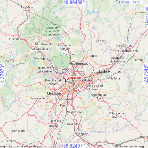
Chamartín GPS coordinates[2]
40° 27' 43.416" North, 3° 40' 35.76" West
| Map corner | latitude | longitude |
|---|---|---|
| Upper-left | 40.99489°, | -4.37973° |
| Center: | 40.46206°, | -3.6766° |
| Lower-right: | 39.92497°, | -2.97348° |
| Map W x H: | 119×119 km | = 73.9×73.9mi |
| max Lat: | 43.74134° ⇑62.7% North |
| Chamartín: | 40.46206° |
| min Lat: | ⇓37.3% South 27.64134° |
| min Long | Chamartín | max Long |
| -18.00367° | -3.6766° | 4.2899° |
| W 45%⇐ | ⇒55% E |
Elevation
Elevation of Chamartín is 719 m = 2359 ft, and this is 121 m = 397 ft above average elevation for this country.
| Max E: |
1682 m = 5518 ft | 43.6% |
| Chamartín | 719 m 2359 ft | |
| Avg. | 598 m = 1962 ft | |
Min E: |
0 m = 0 ft | 56.4% |
See also: Chamartín elevation on elevation.city.
Geographical zone
Chamartín is located in North temperate zone (between Tropic of Cancer and the Arctic Circle). Distance of this Northern Tropic circle is 1893 km =1176.3 mi to South.| Distance of | km | miles | from Chamartín |
|---|---|---|---|
| North Pole | 5508.1 | 3422.6 | to North |
| Arctic Circle | 2902.2 | 1803.3 | to North |
| Tropic Cancer | 1893 | 1176.3 | to South |
| Equator | 4499 | 2795.5 | to South |


Nearby cities:
15 places around Chamartín: (largest is in red/bold)
• Arganzuela
7.1 km =4.4 mi,  193°
193°
• Chamberí
3.9 km =2.4 mi,  216°
216°
• City Center
5.3 km =3.3 mi,  204°
204°
• Ciudad Lineal
2.9 km =1.8 mi,  131°
131°
• Fuencarral-El Pardo
6.1 km =3.8 mi,  311°
311°
• Hortaleza
3.3 km =2.1 mi,  65°
65°
• Las Tablas
5 km =3.1 mi,  4°
4°
• Madrid
5.5 km =3.4 mi, 203°
• Moncloa-Aravaca
5.5 km =3.4 mi,  237°
237°
• Moratalaz
6.5 km =4 mi,  159°
159°
• Pinar de Chamartín
2 km =1.2 mi,  20°
20°
• Retiro
5.5 km =3.4 mi, 185°
• Salamanca
3.6 km =2.2 mi,  184°
184°
• San Blas-Canillejas
5.8 km =3.6 mi,  116°
116°
• Tetuán de las Victorias
1.8 km =1.1 mi,  261°
261°
Sources, notices
• [Note1] Compared only with cities in Spain existing in our database
• [Src1] Map data: © OpenStreetMap contributors (CC-BY-SA)
• [Src2] Other city data from geonames.org with taken over terms of usage.
• [Src3] Geographical zone / Annual Mean Temperature by Robert A. Rohde @ Wikipedia
