Salamanca geodata
Salamanca (Madrid) is a section of populated place; located in Spain in Europe/Madrid (GMT+2) time zone. With population of 147,707 people, there are 62 cities with bigger population in this country. Compared to other cities in Spain, 63.3% of cities are located further ↑North; 55% of cities are located further →East and 53.8% of cities have lower elevation than Salamanca. Note1
Administrative division(s):
- Level 1: Madrid
- Level 2: Provincia de Madrid
- Level 3: Madrid
- Level 4: Salamanca


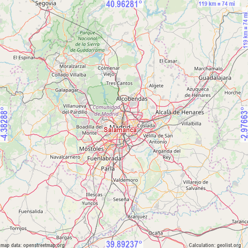
Salamanca GPS coordinates[2]
40° 25' 46.992" North, 3° 40' 47.1" West
| Map corner | latitude | longitude |
|---|---|---|
| Upper-left | 40.96281°, | -4.38288° |
| Center: | 40.42972°, | -3.67975° |
| Lower-right: | 39.89237°, | -2.97663° |
| Map W x H: | 119×119 km | = 73.9×73.9mi |
| max Lat: | 43.74134° ⇑63.3% North |
| Salamanca: | 40.42972° |
| min Lat: | ⇓36.7% South 27.64134° |
| min Long | Salamanca | max Long |
| -18.00367° | -3.67975° | 4.2899° |
| W 45%⇐ | ⇒55% E |
Elevation
Elevation of Salamanca is 698 m = 2290 ft, and this is 100 m = 328 ft above average elevation for this country.
| Max E: |
1682 m = 5518 ft | 46.2% |
| Salamanca | 698 m 2290 ft | |
| Avg. | 598 m = 1962 ft | |
Min E: |
0 m = 0 ft | 53.8% |
See also: Salamanca elevation on elevation.city.
Geographical zone
Salamanca is located in North temperate zone (between Tropic of Cancer and the Arctic Circle). Distance of this Northern Tropic circle is 1889.4 km =1174 mi to South.| Distance of | km | miles | from Salamanca |
|---|---|---|---|
| North Pole | 5511.7 | 3424.8 | to North |
| Arctic Circle | 2905.8 | 1805.6 | to North |
| Tropic Cancer | 1889.4 | 1174 | to South |
| Equator | 4495.4 | 2793.3 | to South |


Nearby cities:
15 places around Salamanca: (largest is in red/bold)
• Arganzuela
3.6 km =2.2 mi,  202°
202°
• Carabanchel
5.7 km =3.5 mi,  221°
221°
• Chamartín
3.6 km =2.2 mi,  4°
4°
• Chamberí
2.1 km =1.3 mi,  283°
283°
• City Center
2.3 km =1.4 mi,  236°
236°
• Ciudad Lineal
2.9 km =1.8 mi,  54°
54°
• Madrid
2.4 km =1.5 mi,  232°
232°
• Moncloa-Aravaca
4.4 km =2.7 mi, 278°
• Moratalaz
3.6 km =2.2 mi,  133°
133°
• Pinar de Chamartín
5.6 km =3.5 mi,  9°
9°
• Puente de Vallecas
4.3 km =2.7 mi,  159°
159°
• Retiro
1.9 km =1.2 mi,  188°
188°
• San Blas-Canillejas
5.5 km =3.4 mi,  79°
79°
• Tetuán de las Victorias
3.7 km =2.3 mi,  335°
335°
• Usera
4.9 km =3 mi, 200°
Sources, notices
• [Note1] Compared only with cities in Spain existing in our database
• [Src1] Map data: © OpenStreetMap contributors (CC-BY-SA)
• [Src2] Other city data from geonames.org with taken over terms of usage.
• [Src3] Geographical zone / Annual Mean Temperature by Robert A. Rohde @ Wikipedia
