Valdezorras geodata
Valdezorras (Andalusia) is a populated place; located in Spain in Europe/Madrid (GMT+2) time zone. With population of 3,000 people, there are 1721 cities with bigger population in this country. Compared to other cities in Spain, 91.7% of cities are located further ↑North; 85.1% of cities are located further →East and 95.1% of cities have higher elevation than Valdezorras. Note1


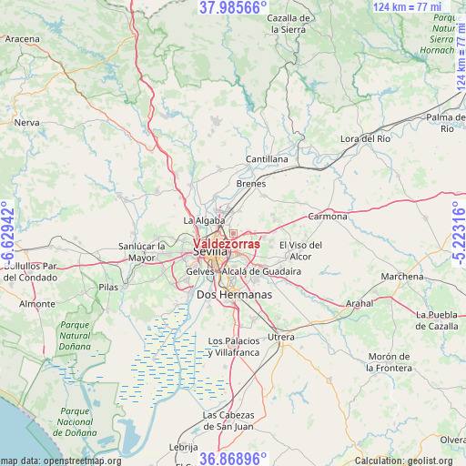
Valdezorras GPS coordinates[2]
37° 25' 45.804" North, 5° 55' 34.644" West
| Map corner | latitude | longitude |
|---|---|---|
| Upper-left | 37.98566°, | -6.62942° |
| Center: | 37.42939°, | -5.92629° |
| Lower-right: | 36.86896°, | -5.22316° |
| Map W x H: | 124.2×124.2 km | = 77.2×77.2mi |
| max Lat: | 43.74134° ⇑91.7% North |
| Valdezorras: | 37.42939° |
| min Lat: | ⇓8.3% South 27.64134° |
| min Long | Valdezorras | max Long |
| -18.00367° | -5.92629° | 4.2899° |
| W 14.9%⇐ | ⇒85.1% E |
Elevation
Elevation of Valdezorras is 24 m = 79 ft, and this is 574 m = 1883 ft below average elevation for this country.
| Max E: |
1682 m = 5518 ft | 95.1% |
| Avg. | 598 m = 1962 ft | |
| Valdezorras | 24 m = 79 ft | |
Min E: |
0 m = 0 ft | 4.9% |
See also: Spain elevation on elevation.city.
Geographical zone
Valdezorras is located in North temperate zone (between Tropic of Cancer and the Arctic Circle). Distance of this Northern Tropic circle is 1555.8 km =966.7 mi to South.| Distance of | km | miles | from Valdezorras |
|---|---|---|---|
| North Pole | 5845.3 | 3632.1 | to North |
| Arctic Circle | 3239.4 | 2012.9 | to North |
| Tropic Cancer | 1555.8 | 966.7 | to South |
| Equator | 4161.8 | 2586 | to South |


Nearby cities:
15 places around Valdezorras: (largest is in red/bold)
• Alcalá de Guadaira
12.7 km =7.9 mi,  142°
142°
• Alcalá del Río
11 km =6.8 mi,  333°
333°
• Brenes
14.2 km =8.8 mi,  19°
19°
• Camas
9.9 km =6.2 mi,  252°
252°
• Castilleja de Guzmán
11.6 km =7.2 mi,  259°
259°
• Castilleja de la Cuesta
12.2 km =7.6 mi, 246°
• Gelves
13.7 km =8.5 mi,  219°
219°
• Gines
14.2 km =8.8 mi, 250°
• La Algaba
8.4 km =5.2 mi,  296°
296°
• La Rinconada
7.9 km =4.9 mi,  322°
322°
• San Juan de Aznalfarache
12.6 km =7.8 mi,  231°
231°
• Santiponce
10.2 km =6.3 mi,  273°
273°
• Sevilla
6.6 km =4.1 mi, 218°
• Tomares
12.3 km =7.6 mi,  239°
239°
• Valencina de la Concepción
13.1 km =8.1 mi, 263°
Sources, notices
• [Note1] Compared only with cities in Spain existing in our database
• [Src1] Map data: © OpenStreetMap contributors (CC-BY-SA)
• [Src2] Other city data from geonames.org with taken over terms of usage.
• [Src3] Geographical zone / Annual Mean Temperature by Robert A. Rohde @ Wikipedia
