Alcalá de Guadaira geodata
Alcalá de Guadaira (Andalusia) is a populated place; located in Spain in Europe/Madrid (GMT+2) time zone. With population of 70,155 people, there are 131 cities with bigger population in this country. Compared to other cities in Spain, 92.7% of cities are located further ↑North; 83.8% of cities are located further →East and 89.7% of cities have higher elevation than Alcalá de Guadaira. Note1
Administrative division(s):
- Level 1: Andalusia
- Level 2: Provincia de Sevilla
- Level 3: Alcalá de Guadaíra


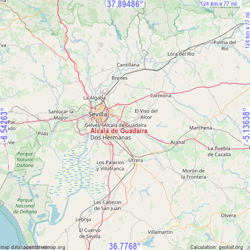
Alcalá de Guadaira GPS coordinates[2]
37° 20' 16.476" North, 5° 50' 22.236" West
| Map corner | latitude | longitude |
|---|---|---|
| Upper-left | 37.89486°, | -6.54263° |
| Center: | 37.33791°, | -5.83951° |
| Lower-right: | 36.7768°, | -5.13638° |
| Map W x H: | 124.3×124.3 km | = 77.2×77.2mi |
| max Lat: | 43.74134° ⇑92.7% North |
| Alcalá de Guadaira: | 37.33791° |
| min Lat: | ⇓7.3% South 27.64134° |
| min Long | Alcalá de Guad | max Long |
| -18.00367° | -5.83951° | 4.2899° |
| W 16.2%⇐ | ⇒83.8% E |
Elevation
Elevation of Alcalá de Guadaira is 71 m = 233 ft, and this is 527 m = 1729 ft below average elevation for this country.
| Max E: |
1682 m = 5518 ft | 89.7% |
| Avg. | 598 m = 1962 ft | |
| Alcalá de Guadaira | 71 m = 233 ft | |
Min E: |
0 m = 0 ft | 10.3% |
See also: Alcalá de Guadaira elevation on elevation.city.
Geographical zone
Alcalá de Guadaira is located in North temperate zone (between Tropic of Cancer and the Arctic Circle). Distance of this Northern Tropic circle is 1545.7 km =960.5 mi to South.| Distance of | km | miles | from Alcalá de Guadaira |
|---|---|---|---|
| North Pole | 5855.5 | 3638.4 | to North |
| Arctic Circle | 3249.6 | 2019.2 | to North |
| Tropic Cancer | 1545.7 | 960.5 | to South |
| Equator | 4151.6 | 2579.7 | to South |


Nearby cities:
15 places around Alcalá de Guadaira: (largest is in red/bold)
• Camas
18.5 km =11.5 mi,  292°
292°
• Castilleja de la Cuesta
19.6 km =12.2 mi, 285°
• Coria del Río
19.8 km =12.3 mi,  253°
253°
• Dos Hermanas
9.4 km =5.8 mi,  229°
229°
• El Viso del Alcor
12.1 km =7.5 mi,  60°
60°
• Gelves
16.5 km =10.3 mi,  268°
268°
• La Algaba
20.6 km =12.8 mi,  312°
312°
• Mairena del Alcor
8.9 km =5.5 mi, 63°
• Mairena del Aljarafe
19.9 km =12.4 mi, 272°
• Palomares del Río
19.5 km =12.1 mi,  264°
264°
• San Juan de Aznalfarache
17.6 km =10.9 mi,  277°
277°
• Sevilla
12.8 km =8 mi, 292°
• Tomares
18.6 km =11.6 mi, 282°
• Utrera
17.8 km =11.1 mi,  163°
163°
• Valdezorras
12.7 km =7.9 mi,  322°
322°
In other languages:
- In Spanish: Alcalá de Guadaíra
- In France: Alcalá de Guadaira, Alcalá de Guadaíra
- In German: Alcalá de Guadaíra
- In Russian: Алькала-де-Гвадаира
Sources, notices
• [Note1] Compared only with cities in Spain existing in our database
• [Src1] Map data: © OpenStreetMap contributors (CC-BY-SA)
• [Src2] Other city data from geonames.org with taken over terms of usage.
• [Src3] Geographical zone / Annual Mean Temperature by Robert A. Rohde @ Wikipedia
