Levi geodata
Levi (Lapland) is a populated place; located in Finland in Europe/Helsinki (GMT+3) time zone. With population of 600 people, there are 437 cities with bigger population in this country. Compared to other cities in Finland, 98.9% of cities are located further ↓South; 50.9% of cities are located further ←West and 99.1% of cities have lower elevation than Levi. Note1


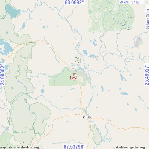
Levi GPS coordinates[2]
67° 48' 18.324" North, 24° 47' 46.104" East
| Map corner | latitude | longitude |
|---|---|---|
| Upper-left | 68.0692°, | 24.09302° |
| Center: | 67.80509°, | 24.79614° |
| Lower-right: | 67.53796°, | 25.49927° |
| Map W x H: | 59.1×59.1 km | = 36.7×36.7mi |
| max Lat: | 69.90864° ⇑1.1% North |
| Levi: | 67.80509° |
| min Lat: | ⇓98.9% South 59.83333° |
| min Long | Levi | max Long |
| 21.2° | 24.79614° | 30.93276° |
| W 50.9%⇐ | ⇒49.1% E |
Elevation
Elevation of Levi is 208 m = 682 ft, and this is 130.9 m = 429 ft above average elevation for this country.
| Max E: |
299 m = 981 ft | 0.90000000000001% |
| Levi | 208 m 682 ft | |
| Avg. | 77.1 m = 253 ft | |
Min E: |
1 m = 3 ft | 99.1% |
See also: Finland elevation on elevation.city.
Geographical zone
Levi is located in North Frigid zone (between North Pole and Arctic Circle). Distance of this North polar circle is 138 km =85.7 mi to South.| Distance of | km | miles | from Levi |
|---|---|---|---|
| North Pole | 2467.8 | 1533.4 | to North |
| Arctic Circle | 138 | 85.7 | to South |
| Tropic Cancer | 4933.3 | 3065.4 | to South |
| Equator | 7539.2 | 4684.6 | to South |


Nearby cities:
15 places around Levi: (largest is in red/bold)
• Enontekiö
80.6 km =50.1 mi,  323°
323°
• Inari
152.8 km =94.9 mi,  36°
36°
• Ivalo
147.7 km =91.8 mi,  49°
49°
• Kemijärvi
166 km =103.1 mi,  137°
137°
• Kittilä
16.1 km =10 mi,  165°
165°
• Kolari
68.2 km =42.4 mi,  219°
219°
• Muonio
48.6 km =30.2 mi,  289°
289°
• Pelkosenniemi
139.1 km =86.4 mi,  123°
123°
• Pello
120.1 km =74.6 mi,  197°
197°
• Pyhäjärvi
131.7 km =81.8 mi,  128°
128°
• Rovaniemi
150.5 km =93.5 mi,  164°
164°
• Savukoski
153.7 km =95.5 mi,  111°
111°
• Sodankylä
87.8 km =54.6 mi, 119°
• Tervola
191.4 km =118.9 mi,  179°
179°
• Ylitornio
173.3 km =107.7 mi, 196°
Sources, notices
• [Note1] Compared only with cities in Finland existing in our database
• [Src1] Map data: © OpenStreetMap contributors (CC-BY-SA)
• [Src2] Other city data from geonames.org with taken over terms of usage.
• [Src3] Geographical zone / Annual Mean Temperature by Robert A. Rohde @ Wikipedia
