Pello geodata
Pello (Lapland) is a seat of a third-order administrative division; located in Finland in Europe/Helsinki (GMT+3) time zone. With population of 4,542 people, there are 226 cities with bigger population in this country. Compared to other cities in Finland, 97.2% of cities are located further ↓South; 61.1% of cities are located further →East and 60.3% of cities have higher elevation than Pello. Note1


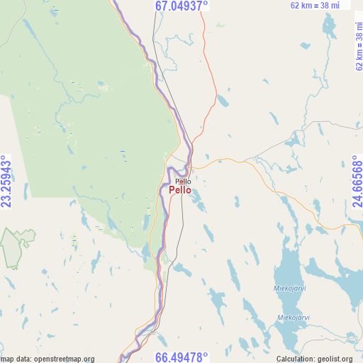
Pello GPS coordinates[2]
66° 46' 25.104" North, 23° 57' 45.18" East
| Map corner | latitude | longitude |
|---|---|---|
| Upper-left | 67.04937°, | 23.25943° |
| Center: | 66.77364°, | 23.96255° |
| Lower-right: | 66.49478°, | 24.66568° |
| Map W x H: | 61.7×61.7 km | = 38.3×38.3mi |
| max Lat: | 69.90864° ⇑2.8% North |
| Pello: | 66.77364° |
| min Lat: | ⇓97.2% South 59.83333° |
| min Long | Pello | max Long |
| 21.2° | 23.96255° | 30.93276° |
| W 38.9%⇐ | ⇒61.1% E |
Elevation
Elevation of Pello is 61 m = 200 ft, and this is 16.1 m = 53 ft below average elevation for this country.
| Max E: |
299 m = 981 ft | 60.3% |
| Avg. | 77.1 m = 253 ft | |
| Pello | 61 m = 200 ft | |
Min E: |
1 m = 3 ft | 39.7% |
See also: Finland elevation on elevation.city.
Geographical zone
Pello is located in North Frigid zone (between North Pole and Arctic Circle). Distance of this North polar circle is 23.4 km =14.5 mi to South.| Distance of | km | miles | from Pello |
|---|---|---|---|
| North Pole | 2582.5 | 1604.7 | to North |
| Arctic Circle | 23.4 | 14.5 | to South |
| Tropic Cancer | 4818.6 | 2994.1 | to South |
| Equator | 7424.5 | 4613.4 | to South |


Nearby cities:
15 places around Pello: (largest is in red/bold)
• Kemi
118.4 km =73.6 mi,  166°
166°
• Keminmaa
111.2 km =69.1 mi, 166°
• Kittilä
106.9 km =66.4 mi,  22°
22°
• Kolari
62.4 km =38.8 mi,  352°
352°
• Kuivaniemi
143.8 km =89.4 mi,  157°
157°
• Levi
120.1 km =74.6 mi, 17°
• Muonio
131.3 km =81.6 mi,  355°
355°
• Pyhäjärvi
145.6 km =90.5 mi,  76°
76°
• Ranua
149.1 km =92.6 mi,  129°
129°
• Rovaniemi
83.1 km =51.6 mi,  111°
111°
• Simo
132.4 km =82.3 mi, 158°
• Sodankylä
134.7 km =83.7 mi,  57°
57°
• Tervola
85.3 km =53 mi,  154°
154°
• Tornio
103.2 km =64.1 mi,  175°
175°
• Ylitornio
53.2 km =33.1 mi,  193°
193°
Sources, notices
• [Note1] Compared only with cities in Finland existing in our database
• [Src1] Map data: © OpenStreetMap contributors (CC-BY-SA)
• [Src2] Other city data from geonames.org with taken over terms of usage.
• [Src3] Geographical zone / Annual Mean Temperature by Robert A. Rohde @ Wikipedia
