Vaasa geodata
Vaasa (Ostrobothnia) is a seat of a first-order administrative division; located in Finland in Europe/Helsinki (GMT+3) time zone. With population of 57,014 people, there are 11 cities with bigger population in this country. Compared to other cities in Finland, 72.9% of cities are located further ↓South; 97% of cities are located further →East and 95.1% of cities have higher elevation than Vaasa. Note1


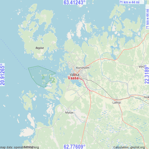
Vaasa GPS coordinates[2]
63° 5' 45.6" North, 21° 36' 56.772" East
| Map corner | latitude | longitude |
|---|---|---|
| Upper-left | 63.41243°, | 20.91265° |
| Center: | 63.096°, | 21.61577° |
| Lower-right: | 62.77609°, | 22.3189° |
| Map W x H: | 70.8×70.8 km | = 44×44mi |
| max Lat: | 69.90864° ⇑27.1% North |
| Vaasa: | 63.096° |
| min Lat: | ⇓72.9% South 59.83333° |
| min Long | Vaasa | max Long |
| 21.2° | 21.61577° | 30.93276° |
| W 3%⇐ | ⇒97% E |
Elevation
Elevation of Vaasa is 7 m = 23 ft, and this is 70.1 m = 230 ft below average elevation for this country.
| Max E: |
299 m = 981 ft | 95.1% |
| Avg. | 77.1 m = 253 ft | |
| Vaasa | 7 m = 23 ft | |
Min E: |
1 m = 3 ft | 4.9% |
See also: Vaasa elevation on elevation.city.
Geographical zone
Vaasa is located in North temperate zone (between Tropic of Cancer and the Arctic Circle). Distance of this North polar circle is 385.6 km =239.6 mi to North.| Distance of | km | miles | from Vaasa |
|---|---|---|---|
| North Pole | 2991.4 | 1858.8 | to North |
| Arctic Circle | 385.6 | 239.6 | to North |
| Tropic Cancer | 4409.7 | 2740.1 | to South |
| Equator | 7015.6 | 4359.3 | to South |


Nearby cities:
15 places around Vaasa: (largest is in red/bold)
• Hietalahti
1.2 km =0.7 mi,  176°
176°
• Isokyrö
37.3 km =23.2 mi,  104°
104°
• Jurva
49.5 km =30.8 mi,  157°
157°
• Korsholm
3.9 km =2.4 mi,  58°
58°
• Korsnäs
40.6 km =25.2 mi,  211°
211°
• Laihia
24 km =14.9 mi,  123°
123°
• Malax
17.2 km =10.7 mi,  187°
187°
• Oravais
44.5 km =27.7 mi, 59°
• Replot
17.8 km =11.1 mi,  325°
325°
• Ristinummi
5.4 km =3.4 mi,  94°
94°
• Smedsby
4.8 km =3 mi, 61°
• Teeriniemi
4 km =2.5 mi, 88°
• Vähäkyrö
25.1 km =15.6 mi, 100°
• Vörå
32.3 km =20.1 mi,  82°
82°
• Ylistaro
48.5 km =30.1 mi,  111°
111°
Sources, notices
• [Note1] Compared only with cities in Finland existing in our database
• [Src1] Map data: © OpenStreetMap contributors (CC-BY-SA)
• [Src2] Other city data from geonames.org with taken over terms of usage.
• [Src3] Geographical zone / Annual Mean Temperature by Robert A. Rohde @ Wikipedia
