Särkisalo geodata
Särkisalo (Southwest Finland) is a seat of a third-order administrative division; located in Finland in Europe/Helsinki (GMT+3) time zone. In our database, there are 443 cities with bigger population. Compared to other cities in Finland, 98.5% of cities are located further ↑North; 76.3% of cities are located further →East and 100% of cities have higher elevation than Särkisalo. Note1


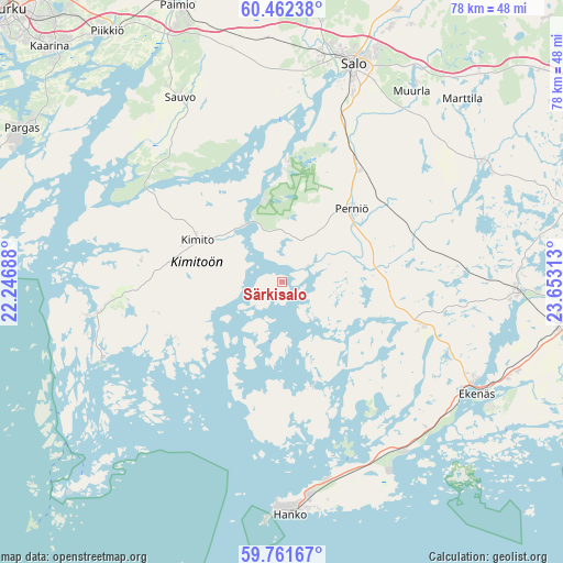
Särkisalo GPS coordinates[2]
60° 6' 50.004" North, 22° 57' 0" East
| Map corner | latitude | longitude |
|---|---|---|
| Upper-left | 60.46238°, | 22.24688° |
| Center: | 60.11389°, | 22.95° |
| Lower-right: | 59.76167°, | 23.65313° |
| Map W x H: | 77.9×77.9 km | = 48.4×48.4mi |
| max Lat: | 69.90864° ⇑98.5% North |
| Särkisalo: | 60.11389° |
| min Lat: | ⇓1.5% South 59.83333° |
| min Long | Särkisalo | max Long |
| 21.2° | 22.95° | 30.93276° |
| W 23.7%⇐ | ⇒76.3% E |
Elevation
Elevation of Särkisalo is 1 m = 3 ft, and this is 76.1 m = 250 ft below average elevation for this country.
| Max E: |
299 m = 981 ft | 100% |
| Avg. | 77.1 m = 253 ft | |
| Särkisalo | 1 m = 3 ft | |
Min E: |
1 m = 3 ft | 0% |
See also: Finland elevation on elevation.city.
Geographical zone
Särkisalo is located in North temperate zone (between Tropic of Cancer and the Arctic Circle). Distance of this North polar circle is 717.1 km =445.6 mi to North.| Distance of | km | miles | from Särkisalo |
|---|---|---|---|
| North Pole | 3323 | 2064.8 | to North |
| Arctic Circle | 717.1 | 445.6 | to North |
| Tropic Cancer | 4078.1 | 2534 | to South |
| Equator | 6684 | 4153.2 | to South |


Nearby cities:
15 places around Särkisalo: (largest is in red/bold)
• Dragsfjärd
26.4 km =16.4 mi,  258°
258°
• Ekenäs
31.1 km =19.3 mi,  120°
120°
• Halikko
32.7 km =20.3 mi,  13°
13°
• Hanko
31.2 km =19.4 mi,  180°
180°
• Karis
39.7 km =24.7 mi,  96°
96°
• Kimito
13.3 km =8.3 mi,  292°
292°
• Kisko
32.3 km =20.1 mi,  65°
65°
• Muurla
32.1 km =19.9 mi,  35°
35°
• Paimio
40.8 km =25.4 mi,  339°
339°
• Perniö
13.9 km =8.6 mi,  46°
46°
• Pertteli
39.6 km =24.6 mi,  26°
26°
• Pohja
32.1 km =19.9 mi,  93°
93°
• Salo
31.6 km =19.6 mi,  18°
18°
• Sauvo
29.1 km =18.1 mi,  331°
331°
• Västanfjärd
16.4 km =10.2 mi,  244°
244°
Sources, notices
• [Note1] Compared only with cities in Finland existing in our database
• [Src1] Map data: © OpenStreetMap contributors (CC-BY-SA)
• [Src2] Other city data from geonames.org with taken over terms of usage.
• [Src3] Geographical zone / Annual Mean Temperature by Robert A. Rohde @ Wikipedia
