Hanko geodata
Hanko (Uusimaa) is a seat of a third-order administrative division; located in Finland in Europe/Helsinki (GMT+3) time zone. With population of 9,962 people, there are 107 cities with bigger population in this country. Compared to other cities in Finland, 100% of cities are located further ↑North; 76.3% of cities are located further →East and 87.6% of cities have higher elevation than Hanko. Note1


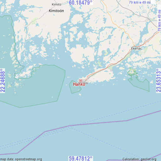
Hanko GPS coordinates[2]
59° 49' 59.988" North, 22° 57' 0" East
| Map corner | latitude | longitude |
|---|---|---|
| Upper-left | 60.18479°, | 22.24688° |
| Center: | 59.83333°, | 22.95° |
| Lower-right: | 59.47812°, | 23.65313° |
| Map W x H: | 78.6×78.6 km | = 48.8×48.8mi |
| max Lat: | 69.90864° ⇑100% North |
| Hanko: | 59.83333° |
| min Lat: | ⇓0% South 59.83333° |
| min Long | Hanko | max Long |
| 21.2° | 22.95° | 30.93276° |
| W 23.7%⇐ | ⇒76.3% E |
Elevation
Elevation of Hanko is 14 m = 46 ft, and this is 63.1 m = 207 ft below average elevation for this country.
| Max E: |
299 m = 981 ft | 87.6% |
| Avg. | 77.1 m = 253 ft | |
| Hanko | 14 m = 46 ft | |
Min E: |
1 m = 3 ft | 12.4% |
See also: Finland elevation on elevation.city.
Geographical zone
Hanko is located in North temperate zone (between Tropic of Cancer and the Arctic Circle). Distance of this North polar circle is 748.3 km =465 mi to North.| Distance of | km | miles | from Hanko |
|---|---|---|---|
| North Pole | 3354.2 | 2084.2 | to North |
| Arctic Circle | 748.3 | 465 | to North |
| Tropic Cancer | 4046.9 | 2514.6 | to South |
| Equator | 6652.8 | 4133.9 | to South |


Nearby cities:
15 places around Hanko: (largest is in red/bold)
• Dragsfjärd
36.7 km =22.8 mi,  314°
314°
• Ekenäs
31.2 km =19.4 mi,  59°
59°
• Ingå
63.3 km =39.3 mi,  68°
68°
• Karis
47.7 km =29.6 mi, 56°
• Karjalohja
62.2 km =38.6 mi,  43°
43°
• Kimito
38.4 km =23.9 mi,  341°
341°
• Kisko
53.4 km =33.2 mi,  33°
33°
• Muurla
60.3 km =37.5 mi,  17°
17°
• Perniö
42 km =26.1 mi,  14°
14°
• Pohja
43.5 km =27 mi,  47°
47°
• Salo
62 km =38.5 mi, 9°
• Sauvo
58.4 km =36.3 mi,  346°
346°
• Särkisalo
31.2 km =19.4 mi,  0°
0°
• Västanfjärd
28.3 km =17.6 mi,  328°
328°
• Väståboland
63.2 km =39.3 mi, 325°
Sources, notices
• [Note1] Compared only with cities in Finland existing in our database
• [Src1] Map data: © OpenStreetMap contributors (CC-BY-SA)
• [Src2] Other city data from geonames.org with taken over terms of usage.
• [Src3] Geographical zone / Annual Mean Temperature by Robert A. Rohde @ Wikipedia
