Dragsfjärd geodata
Dragsfjärd (Southwest Finland) is a seat of a third-order administrative division; located in Finland in Europe/Helsinki (GMT+3) time zone. With population of 3,309 people, there are 280 cities with bigger population in this country. Compared to other cities in Finland, 99.1% of cities are located further ↑North; 84% of cities are located further →East and 79.9% of cities have higher elevation than Dragsfjärd. Note1


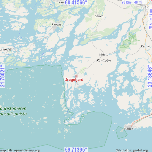
Dragsfjärd GPS coordinates[2]
60° 4' 0.012" North, 22° 28' 59.988" East
| Map corner | latitude | longitude |
|---|---|---|
| Upper-left | 60.41566°, | 21.78021° |
| Center: | 60.06667°, | 22.48333° |
| Lower-right: | 59.71395°, | 23.18646° |
| Map W x H: | 78×78 km | = 48.5×48.5mi |
| max Lat: | 69.90864° ⇑99.1% North |
| Dragsfjärd: | 60.06667° |
| min Lat: | ⇓0.9% South 59.83333° |
| min Long | Dragsfjärd | max Long |
| 21.2° | 22.48333° | 30.93276° |
| W 16%⇐ | ⇒84% E |
Elevation
Elevation of Dragsfjärd is 19 m = 62 ft, and this is 58.1 m = 191 ft below average elevation for this country.
| Max E: |
299 m = 981 ft | 79.9% |
| Avg. | 77.1 m = 253 ft | |
| Dragsfjärd | 19 m = 62 ft | |
Min E: |
1 m = 3 ft | 20.1% |
See also: Finland elevation on elevation.city.
Geographical zone
Dragsfjärd is located in North temperate zone (between Tropic of Cancer and the Arctic Circle). Distance of this North polar circle is 722.4 km =448.9 mi to North.| Distance of | km | miles | from Dragsfjärd |
|---|---|---|---|
| North Pole | 3328.3 | 2068.1 | to North |
| Arctic Circle | 722.4 | 448.9 | to North |
| Tropic Cancer | 4072.9 | 2530.8 | to South |
| Equator | 6678.8 | 4150 | to South |


Nearby cities:
15 places around Dragsfjärd: (largest is in red/bold)
• Hanko
36.7 km =22.8 mi,  134°
134°
• Kaarina
38.4 km =23.9 mi,  350°
350°
• Kimito
17.1 km =10.6 mi,  52°
52°
• Lieto
49.3 km =30.6 mi,  358°
358°
• Nagu
34.8 km =21.6 mi,  293°
293°
• Paimio
44.8 km =27.8 mi,  14°
14°
• Pargas
28.5 km =17.7 mi,  339°
339°
• Perniö
38.9 km =24.2 mi,  67°
67°
• Piikkiö
39.9 km =24.8 mi,  2°
2°
• Rymättylä
45.6 km =28.3 mi,  319°
319°
• Sauvo
32.9 km =20.4 mi,  20°
20°
• Särkisalo
26.4 km =16.4 mi,  78°
78°
• Turku
44.4 km =27.6 mi, 344°
• Västanfjärd
11.3 km =7 mi,  99°
99°
• Väståboland
27.8 km =17.3 mi, 338°
Sources, notices
• [Note1] Compared only with cities in Finland existing in our database
• [Src1] Map data: © OpenStreetMap contributors (CC-BY-SA)
• [Src2] Other city data from geonames.org with taken over terms of usage.
• [Src3] Geographical zone / Annual Mean Temperature by Robert A. Rohde @ Wikipedia
